This item has been sold, but you can enter your email address to be notified if another example becomes available.


|
||

|

|
|

|
Stock# 65473
Description
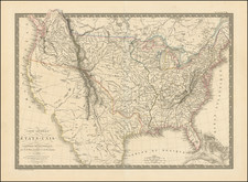
Detailed map of the United States, shortly after the conclusion of the American Civil War.
Montana, Wyoming and Idaho are now clearly and accurately delineated as counties, with only Dakota Territory not yet in its final configuration.
The map provides an exceptionally detailed treatment of the topography of the West, Indian tribal locations American Forts, etc.
From a scarce late edition of Flemming's Atlas.
Condition Description
Minor toning.
![(American Revolution) Geschichte der Revolution von Nord-America. Sammlung der besten Schriftsteller, welche die Geschichte, besondere Rechten, Sitten, und Gewohnheiten der Völker nach ihren Grundsätzen abgehandelt haben [with map:] Die Vereinigten Staaten von Nord=America. nach der Wm. Faden 1783. [History of the Revolution of North America. Collection of the Best Writers Who Have Discussed the History, Specific Laws, Customs, and Habits of the Peoples According to Their Principles [with map:] The United States of North America. According to Wm. Faden, 1783.]](https://storage.googleapis.com/raremaps/img/small/90124.jpg)

![[ Rotary Club International ] USCB Districts of Rotary International as of 1 July, 1958](https://storage.googleapis.com/raremaps/img/small/90418.jpg)