|
||

|

|
|

|
Rare Wall Map Tracing Movements of Pioneer Mormons Before 1850
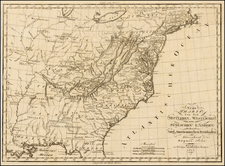
This 1929 wall map, titled Map Showing the Movements of The Church of Jesus Christ of Latter-Day Saints Also the Routes of the Mormon Battalion Zion's Camp and Important Data, compiled by A. William Lund, presents a comprehensive visual record of the pioneer movements of the early Church of Jesus Christ of Latter-Day Saints across the United States before 1850. The map, a result of research and careful drafting, was published by the Deseret Book Company and Wheelwright Lithographing Company, both located in Salt Lake City, Utah.
Created during a time of historical awakening within the Church, approximately eighty years after their renowned westward migration, this map not only delineates geographical trajectories but also captures the endurance and resilience of the Mormon pioneers. As such, it chronicles three essential movements: the march of the Mormon pioneers to Salt Lake, the routes of the Mormon Battalion, and the path of Zion's Camp. Each of these journeys had a profound impact on the growth and development of the early Church, and their trace on this map speaks to the lengths these pioneers were willing to go to secure their religious freedom and establish their communities.
A notable aspect of this map is its excellent detail. Each route taken by the pioneers is carefully marked, with dates corresponding to the journey through the United States and Transmississippi West. Lund's commitment to accuracy in detailing these routes reflects a profound respect for the pioneers' experiences, underscoring the significance of each step in their journey.
Additionally, the map spotlights early Mormon settlements in the West, each associated with its respective founder. This documentation of settlement origins allows a unique insight into the Church's expansion, offering names and places that could lead to further individual exploration of these pioneers' lives and contributions.
Complementing the map is an informative index providing critical supplementary information about the Church's history. It offers details such as the dates of the Church's founding and its founding members, descriptions of important places in the Church's history (Colesville, Carthage, Fayette, Far West, Harmony, Independence, Kirtland), as well as an account of various missions and their founders. The index also notes the first Mormon newspapers and their publication dates, languages of the Book of Mormon, the LDS Temples as of 1928, and a list of Church Presidents. Such a range of data collected in one place provides a rich foundation for further study.
Adding to the map's value is a smaller inset map of Wayne and Ontario counties, New York, pinpointing significant locations in early Church history.
Below the main body of the map, there is a list of pioneers of 1847. It highlights the members of the first fourteen companies to enter the Salt Lake Valley and includes a brief list of women and children, giving a human face to the abstract trajectories of migration.
Interestingly, while Sharon, Vermont, and Palmyra, New York are given emphasis, Kirtland and Nauvoo do not have any special notations. This could lead to a deeper examination of the map's underlying choices and the historical or cultural factors influencing these decisions.
In summary, Lund's map, with its intricate details and wealth of additional information, serves as a vital document for anyone seeking to understand the early history and geographical progression of the Church of Jesus Christ of Latter-Day Saints. Its presentation of significant migration paths, settlements, and additional data offers both an overview of the Church's historical evolution and a starting point for more focused studies on specific aspects of its early history.
Rarity
OCLC locates 3 examples (University of Utah, BYU, and the LDS Church Library).
A. William Lund, son of church historian Anthon H. Lund, served a mission to Great Britain from 1906 to 1908
On September 21, 1908, he began working with his father in the Church Historian’s Office. At the time, Anthon Lund was second counselor in the first presidency as well as church historian and recorder. On April 9, 1911, he became assistant church historian, a position he remained in for most of his life.
Lund undertook several publishing projects, including a map showing church trails in the United States and the reprinting of William Clayton’s Latter-day Saints’ Emigrants’ Guide.
Lund served as president of the British Mission from 1928 to 1932. Later, he served as a director of the Genealogical Society of Utah and as a member of the Deseret Sunday School Union general board.
![[United States Independence After The Revolution] A New Map of North America, with the West India Islands, Divided according to the Preliminary Articles of Peace, Signed at Versailles, 20 Jan. 1783, wherein are particularly Distinguished The United States, and the Several Provinces, Governments &ca, which Compose the British Dominions . . . 1783](https://storage.googleapis.com/raremaps/img/small/70734.jpg)