


|
||

|

|
|

|
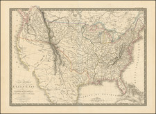
Rare First Edition of One of the Earliest Obtainable Maps To Dhow United States From Coast to Coast
Fine early map of the United States by A.H. Brue, published in Paris.
The map is especially interesting west of the Mississippi, where it shows a double wide Arkansas Territory, Oregon Territory extending from the Mississippi to the Pacific, with fabulous detail in the Pacific Northwest relying upon Lewis & Clark and the Hudson's Bay Co writings, etc. The Spanish colonies west of the Mississippi River are also still shown (St. Louis, Girardeau, Howard, Laurence & Arkansas). The map is one of the most detailed renderings of the drainage systems of the Rockies and Upper Mississippi prior to Nicollet.
Oregon Territory is called "District De La Colombia" and extends north to 54º 40", as claimed by the United States at the time. The watershed of the Columbia River is well defined, based upon the explorations of Lewis & Clark.
West of the Rocky Mountains, two large lakes (Timpanogos and Teguayo) are shown in the Utah area, connected by a river flowing on to the Pacific, called R. S. Phelipe ou del Carmelo. In California, the Missions are located, as is the mythical River of the Martyrs, north of the Colorado River.
The map is also one of the best maps of the US for locating Western Indian Tribes, with more than 3 dozen tribes named.
Several early settlements are shown in Texas. Including Champ D'Axile, which was abandoned in 1818.
States of the Map
The December 1820 imprint is the earliest edition of this map. There are apparently 3 states of the December 1820 edition of the map, each differentiated by the publisher's name. In no particular order:
- A.H. Brue imprint only
- A.H. Brue and J. Goujon
- AH Brue and Chles. Simonneau
The Simonneau and Goujon imprints seem to be considerably rarer than the state with Brue's name alone.
Andre Hubert Brué was a French geographer and cartographer. Born in Paris, he served in the French Navy, joining the Baudin expedition to the Pacific (1800-1804). After his sea service, Brué applied his navigation and charting skills to creating finely-crafted maps, which were renowned for their crisp engraving and accuracy. He drew directly on the copper of the plate, creating what he called encyprotypes. He is best known for the Atlas universal de géographie physique, politique, ancienne et moderne.

![(Anti-Nato Propaganda) Военные Блоки-Оплот Милитаризма [Military Blocs-Strongholds of Imperialism]](https://storage.googleapis.com/raremaps/img/small/94274.jpg)