|
||

|

|
|

|
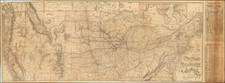
The Pictorial Map of the United States, published by Ensign, Bridgman & Fanning in 1854, is a visually compelling historical artifact. Printed by D. McLellan in New York, this work is notable for being a popular print wall map, scarce in number, and rich in detail.
The map is surrounded by a variety of historical images and references. These include portraits of the U.S. presidents up to that point in time, with notable inclusions of Presidents Pierce and Fillmore. Also depicted are important moments and figures in U.S. history, such as the Landing of the Pilgrims in 1620, the Battle of Monterey in 1846, and the Landing of Columbus in 1492. The map also includes images of important historical events like the Capture of General La Vega during the Mexican-American War, and Perry's Victory during the War of 1812.
The image of the Senate Chamber and the House of Representatives Chamber in Washington, D.C. showcases important political institutions of the U.S., while the large image of the Signers of the Declaration of Independence with their signatures in facsimile gives a nod to the nation's founding fathers.
At the time of this map's creation, the U.S. was undergoing rapid territorial expansion. The map reflects this with its depiction of the large western territories like Utah, Nebraska, Oregon, Washington, Kansas, and New Mexico. The inclusion of a population table further illustrates the growth and development of the country.
In addition, the map showcases various implements of war and agriculture, representing both the country's military strength and its agricultural heritage.
All in all, this map serves as a striking visual encapsulation of the state of the United States in the mid-19th century.
![Charte von den Vereinigten Staaten von Nord=America mit Luisiana Prag 1818 [Rare Florida inset]](https://storage.googleapis.com/raremaps/img/small/72217.jpg)
![United States History-Map (Five historical maps, including Toscanelli's Map of 1474) [Cover title:] Bacon's Excelsior Wall Atlases - America](https://storage.googleapis.com/raremaps/img/small/88839.jpg)