|
||

|

|
|

|
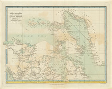
Mapping the Magnetic Polar Party's Route -- 1908-1909
Rare separately published example of the route of the Magnetic Polar Party in search of the South Magnetic Pole Area.
The Magnetic Polar Party of 1908-1909 was a specialized team within the British Antarctic Expedition, also known as the Nimrod Expedition, led by Ernest Shackleton. This expedition took place from 1907 to 1909, with the Magnetic Polar Party specifically focused on geomagnetic research during the latter part of this period.
This team's mission was to reach the South Magnetic Pole and conduct scientific observations related to Earth's magnetic field. At the time, the exact location of the South Magnetic Pole was not precisely determined. The Magnetic Polar Party's goal was to locate this point, where the geomagnetic field lines are vertical, and to gather data on the Earth's magnetic field.
The party included key figures such as geologist Edgeworth David, who led the team, Douglas Mawson, a geologist and Antarctic explorer, and Alistair Mackay, a doctor and explorer. They embarked on their journey to the South Magnetic Pole in late 1908.
Starting from the Depot on McMurdo Sound on the Ross Sea, the map illustrates in red route of the Magnetic Polar Party, on its quest to reach the true South Magnetic Pole Area, where it arrived on June 16, 1909, before returning to Relief Inlet.
The Magnetic Polar Party's expedition, though a part of the larger Nimrod Expedition, stands out for its scientific achievements under challenging conditions. Their work in the Antarctic region provided valuable insights and data for geomagnetic research, marking an important milestone in the early 20th century exploration and scientific study of Antarctica.

![[Alaska, Northwest Coast and North Pacific Ocean] Der Noerdliche Theil des Grossenwelt Meeres . . . 1804](https://storage.googleapis.com/raremaps/img/small/80463.jpg)