|
||

|

|
|

|
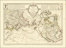
C. G. Reichard's Striking Map of the North Pacific Featuring Cook, Vancouver, and Others
Fine 1804 map showing the northwest coast of North America and the northeast coast of Asia and featuring information from the latest voyages to the region.
Skillfully drawn and labeled in an elegantly simple style, the map delves into great topographical detail on the continents and gives an impressively accurate depiction of this region to that date.
This map shows the North Pacific Ocean and surrounding lands. Asia can be found in the west, including parts of Russia, China, and Japan. North America is visible in the east, from present-day Alaska down through Canada to California (New Albion). The map stretches from the Arctic Ocean (Eis Meer) down to just south of the Tropic of Cancer (Wendekreis des Krebses).
The Bering Sea (here called the Sea of Kamchatka or Meer von Kamtchatka) can be found in the upper center of the map. The Pacific Ocean takes up the majority of the lower half of the map, with a few small islands named, such as the Hawaiian Islands (Di Sandwich Inseln) and the Mariana Islands (Die Marianen oder Ladronen).
Numerous geographical features are included, particularly rivers and mountain ranges. Each river on the map is drawn with close attention to detail, and the thickness of line indicates the river’s width. Lines similar to hachures represent mountain ranges or higher land. This allows the reader to deduce that Eastern Asia is mountainous with many river valleys, while North America’s mountains are contained in ranges along the west coast and somewhat inland.
The map is well labeled, particularly on the coasts but also farther inland on mainland Asia and North America. There are a number of notes that tell the reader where certain information comes from, such as a lake on the northern coast of America whose location is given by the area’s native people.
Additional information is also provided on the people who live in these different places. In the Sea of Okhotsk (Meer von Ochotsk), a note indicates the region as that of the Tungusic people (Tungusen), who trace ancestry to modern-day Russia, Mongolia, and Northern China.
One interesting location can be found in the center of the map, below the 40th parallel. An island is tentatively outlined, and the caption describes it as the likely location of the “big island” which was visited by the Spanish and others after. It is unclear to precisely which island this caption refers, although it could refer to news from the Malaspina expedition (1789-1794), which had not published its findings when this map was published.
Exploration in the North Pacific—the Russians
Throughout the 1700s, a number of exploratory voyages conducted by both Russians and Europeans charted the North Pacific, opening it up to trade and conflict. This map shows the results of several voyages that happened in the decades before the map was made.
One such voyager was Vitus Bering, a Danish sailor who served in the Russian navy and captained the First and Second Kamchatka Expeditions. The First Kamchatka Expedition, which began in 1725, aimed to explore the extent of Siberia and to determine if Asia and North America were connected. The voyage was long and difficult; the crew traveled nineteen months overland from St. Petersburg before even reaching the Pacific coast at Okhotsk. From there, they sailed northeast along the coast of Kamchatka until they reached what would later be known as the Bering Strait (here Bering-Cooks Strasse).
Bering and his crew sailed around the East Cape (here Ost V., today known as Cape Dezhnev) and saw that the coast turned back west toward Russia. He concluded that Asia and America were not connected, and though the expedition would spend another winter at Kamchatka, Bering was unable to locate any land to the east of the East Cape. The crew returned to St. Petersburg in 1730, after five years away.
After criticism for not making contact with America, Bering proposed the Second Kamchatka Expedition. However, during the voyage his ships were separated, weather was poor, and the crew became exhausted and sick. Bering himself became ill and eventually died on what is now known as Bering Island (I. Berings), near the coast of Kamchatka. Despite the deaths of nearly half of the crew, the expedition did eventually return to St. Petersburg with scientific and geographic information, opening the North Pacific to further Russian exploration.
Exploration in the North Pacific—the British
Britain also sent a number of exploratory voyages to the North Pacific, including James Cook’s third voyage in the late 1770s and that of George Vancouver in 1790. Cook’s voyage intended to search for the possible Northwest Passage from the Pacific side, which would allow easier British access to trade with Asia. During the voyage, Cook’s ships stopped at a number of locations on the American coast, where they encountered native traders who had already had extensive contact with Russians and Russian goods. However, a Northwest Passage was never found, and Cook perished on the expedition. His influence is shown here in some of the toponyms in what is today Alaska and in the inclusion of the Hawaiian, or Sandwich Islands, which he encountered on this expedition.
The voyage of Vancouver ten years later also intended to find a Northwest Passage, as well as treat with the Spanish in Canada to solve a land dispute between Spain and Britain. This dispute became known as the Nootka Sound (here Nootka Sund, near New Georgia) Controversy, and it was sparked when the Spanish military seized British trade ships off the coast of Canada. The Spanish claimed they possessed the entirety of North America’s northwest coast, despite not having explored or occupied all of it. The British contested this, threatening war, and Spain eventually yielded to Britain’s greater naval power.
Vancouver was also unable to find a Northwest Passage and eventually he concluded that it did not exist. However, valuable information about the region from his voyage was carefully recorded and published in 1798, hugely improving British knowledge of the Canadian coast and the North Pacific and expanding their control of the area.
Reichard likely also called on the charting of Laperouse in Japan, Kamchatka, and on the coast of what is now Canada. Although Laperouse was lost and his fate unknown at this time, some of his papers had been sent to France before his ships disappeared. He also likely used reports from whalers, some of which were from the young country of the United States.
All of these expeditions would have been influences and references for Reichard as he prepared this map. The map shows labels in multiple languages (Russian, English, and indigenous), reflecting the many sources Reichard drew from and the high amount of interaction between explorers and indigenous people.
In addition, six different scale bars are included to measure distance, including those of China, Russia, England, and France. This allows the map to be useful in and comparable to other maps from countries that had a stake in the region. The map reflects explorations and encounters, expressing the complex relationships between Europe, Asia, and America at this time, which were deeply rooted in both colonization and trade.
Technical Aspects of Mapmaking: The Conic Projection
This map has a conic projection, meaning the parallels curve around the pole in concentric circles while the meridians are straight and equally spaced apart. Reichard was well known for preferring this projection. Therefore, the meridians are closer together near the pole and farther apart away from the pole. This projection allows the map to maintain minimal areal distortion, making it quite accurate on that front. The graticule is clear with both the Tropic of Cancer (Wendekreis des Krebses) and the Arctic Circle (Nordlicher Polar Kreis) labeled.
It is also interesting to note that, although published in Weimar, the longitude lines on this map were measured west from Paris, making Paris the location of the Prime Meridian. Prime Meridians are arbitrarily placed, and before it was internationally standardized, cartographers chose whichever Prime Meridian location they preferred, often one in their home country as a point of nationalistic pride. A few common choices for Prime Meridian locations in this time were Paris, Cadiz, Washington, and Greenwich.
However, in the late 1800s it was decided that a single, internationally recognized Prime Meridian would be useful in the standardization of geographic science. The current location of the Prime Meridian—Greenwich, England—was agreed upon at the first International Meridian Conference in 1884. This map, of course, was published a full 80 years before this standardization, when alternative Prime Meridians were still commonly used.
This is an exceptional map that showcases Reichard’s ability to produce work of both precision and beauty. It would be an impressive addition to a collection of Reichard maps or maps of the Pacific.
Christian Gottlieb Reichard (1758-1837) was a German cartographer. Reichard studied law in Leipzig and found work as a town clerk in Bad Lobenstein. He had great personal interest in geography, history, and cartography, hobbies which gained him more renown than law. However, even after he began making maps, he continued working his clerk job, which gave him the financial stability to support his family.
Reichard is best known for his work on his Atlas des Ganzen Erdkreises in der Central Projection (Atlas of the Whole World in the Central Projection) in 1803 and the Orbis terrarum antiquus (Atlas of the Ancient World) of 1824. He is also likely the first published cartographer to adopt the Albers conic projection, in his map Die Vereinigten Staaten von Nord-America, nach den sichersten Bestimmungen, neuesten Nachrichten und Charten, in der Alber’schen Projection entworfen, (The United States of North America, after the safest regulations, latest news and charts, designed in the Alberian projection), where he references the Albers projection by name.
Reichard’s work was known by his contemporaries as highly accurate, and in fact this descriptor still holds up today. This accuracy, along with his skill, made him very publishable, and he worked on a number of atlases with other cartographers, such as Steiler’s Handatlas. Reichard’s style is simple but includes great detail, making his maps both recognizable at a glance and engaging upon deeper study.
![Tabula Geographica Hemisphaerii Borealis ad emenatiora quae adhuc prodieruntexampla jusqu Acad. Reg. Scient. et Eleg. Litt. Boruss. descripta [with:] Tabula Geographica Hemisphaerii Australis...](https://storage.googleapis.com/raremaps/img/small/81806.jpg)
![[Spitzbergen & Wiches Lande]](https://storage.googleapis.com/raremaps/img/small/61990.jpg)