|
||

|

|
|

|
Stock# 98634
Description
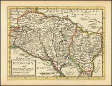
Interesting 19th Century map of Hungary, published in Italian.
The map is divided into Upper and Lower Hungary and subdivided into smaller Circles and Counties.
Lake Balaton is called Lago di Platten.
The map pre-dates the Austro-Hungarian Compromise of 1867, when Transylvania became part of the Kingdom of Hungary.
![[Szigetvár] Ziget, fortezza innespugnabile, si come ogi di è veramente situata . . . M.D. LXVI](https://storage.googleapis.com/raremaps/img/small/92144.jpg)
![(Second World War II - Air Navigation) Vogels Karte von Mitteleuropa [Vogel's Map of Central Europe]](https://storage.googleapis.com/raremaps/img/small/89945.jpg)
![(Italy and Austria) Carta geografica statistica postale dell’I.R. Monarchia Austriaca e dell’Italia [Statistical postal geographic map of the Imperial Royal Austrian Monarchy and of Italy]](https://storage.googleapis.com/raremaps/img/small/94038.jpg)