|
||

|

|
|

|
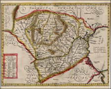
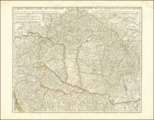
"Hungary and Transilvania Agreeable to Modern History," is a scarce map, published in London in 1729 by Herman Moll. As an early 18th-century representation of these regions, it reflects the geographical understanding of the time and serves as a testament to the development of cartography during this period.
The map is attributed to Herman Moll, an eminent British cartographer of the late 17th and early 18th centuries. A figure of notable influence, Moll's work is well-recognized for its precision and detail. This particular map carries Moll's hallmark quality, featuring detailed geographical elements and place names for Hungary and Transylvania, territories that have been subjects of considerable political and cultural interest throughout history.
The depiction of Hungary and Transylvania in this map reflects the complex political realities of the time. The early 18th century was a period marked by the aftermath of the Great Turkish War (1683-1699), where parts of Hungary were liberated from Ottoman rule and re-incorporated into the Habsburg Empire. The map, therefore, captures a region in transition, offering valuable insights into the shifting political boundaries and territorial claims of the era.
Herman Moll (c. 1654-1732) was one of the most important London mapmakers in the first half of the eighteenth century. Moll was probably born in Bremen, Germany, around 1654. He moved to London to escape the Scanian Wars. His earliest work was as an engraver for Moses Pitt on the production of the English Atlas, a failed work which landed Pitt in debtor's prison. Moll also engraved for Sir Jonas Moore, Grenville Collins, John Adair, and the Seller & Price firm. He published his first original maps in the early 1680s and had set up his own shop by the 1690s.
Moll's work quickly helped him become a member of a group which congregated at Jonathan's Coffee House at Number 20 Exchange Alley, Cornhill, where speculators met to trade stock. Moll's circle included the scientist Robert Hooke, the archaeologist William Stuckley, the authors Jonathan Swift and Daniel Defoe, and the intellectually-gifted pirates William Dampier, Woodes Rogers and William Hacke. From these contacts, Moll gained a great deal of privileged information that was included in his maps.
Over the course of his career, he published dozens of geographies, atlases, and histories, not to mention numerous sheet maps. His most famous works are Atlas Geographus, a monthly magazine that ran from 1708 to 1717, and The World Described (1715-54). He also frequently made maps for books, including those of Dampier’s publications and Swift’s Gulliver’s Travels. Moll died in 1732. It is likely that his plates passed to another contemporary, Thomas Bowles, after this death.
![(Second World War - Soviet Invasion of Romania) [Troop Movements in the Vicinity of Gura Humorului]](https://storage.googleapis.com/raremaps/img/small/89328.jpg)