


|
||

|

|
|

|
Stock# 98308
Description
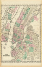
A rare map of New York and its surroundings, from Rogers & Johnston's Atlas of the United States. This map is on a much larger scale than most other maps in this atlas, with the field of view occupying approximately 25 miles. The map shows the layout of the area including streets, neighborhoods, cities, railroads, and other major features. The areas most densely populated are shaded; in Manhattan, this extends to Midtown. Parts of Long Island, Staten Island, and New Jersey are all shown. The New Jersey Railway acts as a western boundary for detail on the map. Newark, Coney Island, Jamaica Bay, Hoboken, and many more neighborhoods and cities are all named.
![[ Tribeca Indenture ] 1790 Indenture Between Robert C. Livingston and Amos Laforgee For Lease of Property on Reade Street in New York City](https://storage.googleapis.com/raremaps/img/small/100514.jpg)

![Rand, McNally & Co's Map of the Main Portion of Brooklyn [on verso] Map of the Southern Portion of New York City](https://storage.googleapis.com/raremaps/img/small/86750.jpg)
