


|
||

|

|
|

|
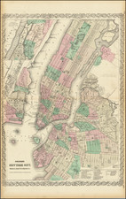
Colton's New York City, Brooklyn, Jersey City, Hoboken Etc, published by GW & CB Colton in 1865, is a detailed map of New York City and vicinity, notable for its orientation with North at the top—a departure from most double-page atlas maps of New York City from this period. This large-format map comprehensively depicts parks, streets, wards, buildings, rail lines, wharfs, and various other features, including an inset of Upper NYC and part of Westchester County. It also extends to cover substantial portions of Brooklyn, Hoboken, and Jersey City.
The year 1865 marked the end of the American Civil War and the beginning of an era of significant transformation in New York City. During this time, the city experienced rapid industrial growth and demographic changes, and its urban landscape was reshaped through new developments and infrastructure. The map captures this dynamic environment, offering a detailed and accurate portrayal of a city in flux, with its expanded boundaries and a complex network of streets, railroads, and buildings.
GW & CB Colton, along with JH Colton, were leading figures in American cartography during the mid-19th century. Their works are distinguished by their accuracy, detail, and visual appeal. This map exemplifies these qualities, providing a clear and comprehensive representation of New York City and its neighboring areas. The inclusion of an inset displaying the upper part of New York City, along with the adjacent portion of Westchester County, enhances the map's value as a historical and geographical resource.
The orientation of the map, with North at the top, is a noteworthy feature that sets it apart from other contemporary maps of New York City. This orientation provides a unique perspective on the city's layout and allows for an intuitive understanding of its geography. It also reflects a cartographic choice that emphasizes the city's connection to the broader region, including Brooklyn, Hoboken, and Jersey City.
In summary, Colton's New York City, Brooklyn, Jersey City, Hoboken Etc stands as an important cartographic document that captures the complexity and vibrancy of New York City during a pivotal moment in its history. Its unusual orientation, combined with its meticulous attention to detail and inclusion of surrounding areas, makes it a significant artifact. It not only serves as a geographical representation but also as a window into the social, economic, and cultural life of New York City at a time of profound transformation. Its depiction of the intricate urban fabric provides a rich source for understanding the city's growth and evolution in the aftermath of the Civil War, reflecting broader trends in American urban development.
G. W. & C. B. Colton was a prominent family firm of mapmakers who were leaders in the American map trade in the nineteenth century. The business was founded by Joseph Hutchins Colton (1800-1893) who bought copyrights to existing maps and oversaw their production. By the 1850s, their output had expanded to include original maps, guidebooks, atlases, and railroad maps. Joseph was succeeded by his sons, George Woolworth (1827-1901) and Charles B. Colton (1831-1916). The firm was renamed G. W. & C. B. Colton as a result. George is thought responsible for their best-known work, the General Atlas, originally published under that title in 1857. In 1898, the brothers merged their business and the firm became Colton, Ohman, & Co., which operated until 1901, when August R. Ohman took on the business alone and dropped the Colton name.


![[ Central Park ]](https://storage.googleapis.com/raremaps/img/small/75716.jpg)
![[Lower East Side / Manhattan] Map of Delancy's Farm Eastern Part.](https://storage.googleapis.com/raremaps/img/small/59384.jpg)