


|
||

|

|
|

|
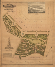
Monumental ink on drafting linen map of Central Park from the first half of the 20th century. The map was almost certainly a city planning document during Robert Moses's tenure as New York City Park Commissioner. It is primarily a schematic of water and electricity infrastructure within the Park, and in that respect, it is exceptionally detailed; for instance, main waterlines within the Central Park Zoo and Metropolitan Museum of Art are shown and labeled.
Dating the Map
The map lacks any obvious maker or dating identification but based on some anachronisms we can come up with an approximate date of in the mid-1930s.
Immediately north of the Great Lawn is an area leading to the Reservoir called "The Promenade" - this was never built.
The footprint of the Metropolitan Museum remained unchanged from 1926 to 1971, and this map comes from that period.
Robert Moses Era
Central Park stands as a testament to the genius of urban planning and landscape architecture. However, while many might associate Central Park with its original designers, Frederick Law Olmsted and Calvert Vaux, the legacy of Robert Moses, New York's "Master Builder," also intersects with this iconic green space.
Central Park was conceived in the 1850s as an answer to the rapidly industrializing city's need for a public recreational space. Olmsted and Vaux's winning design, the "Greensward Plan," showcased a harmonious blend of naturalistic landscapes and constructed elements, transforming an uneven terrain of swamps and bluffs into a pastoral haven. While the park was celebrated upon its completion in the 1870s, by the early 20th century, it had fallen into disrepair due to neglect and mismanagement.
Enter Robert Moses in the 1930s, appointed as the city's Parks Commissioner. Moses undertook an aggressive campaign to revitalize the park. Under his leadership, Central Park saw significant infrastructure development: playgrounds were constructed, ball fields were laid out, and the Central Park Zoo was modernized.
![Southeastern New York [with inset] Vicinity of New York](https://storage.googleapis.com/raremaps/img/small/101125.jpg)
![The Great Metropolis. Phelps' New York City Guide with Maps and Engravings [with:] New York City Map. [and:] Phelp's Illustrated Guide to the Central Park](https://storage.googleapis.com/raremaps/img/small/81795.jpg)