|
||

|

|
|

|
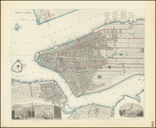
Lower Manhattan and Brooklyn published the year before consolidation
Detailed map of the main portion of Brooklyn, from Metropolitan Avenue south to the north end of Greenwood Cemetery. To the northeast, Brooklyn is bordered by Newtown, a former city encompassing many Queens neighborhoods, and here present-day Ridgewood. Fort Greene Park is still Washington Park, not yet relandscaped by Olmsted and Vaux. Manhattan Bridge was not yet built.
On the verso is a map of the southern part of Manhattan, starting at 38th street. The Financial District was at the time host to various commodities markets, such as the produce exchange by Bowling Green. On Chambers Street to the north of City Hall, is the New York County Courthouse, a controversial project at the time due to its extravagant $13 million cost, much of that embezzled by William "Boss" Tweed and his allies. New York Hospital can be seen at its second location between Fifth and Sixth Avenues and West Fifteenth and Sixteenth Streets before it became affiliated with Cornell University Medical College; it is now the site of The Chelsea Lane.
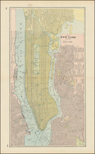
Rand McNally & Co. is a large American map and navigation company best known for its annual atlases. The company got its start in 1856, when William Rand opened a print shop in Chicago. He was joined in 1858 by a new employee, Andrew McNally. Together, the men established their namesake company in 1868. Originally, the company was intended to print the tickets and timetables for the trains running to and through Chicago; their first railway guide was published in 1869.
By 1870, they had shifted from just printing to publishing directories, travel guides, and newspapers. Their first map appeared in 1872 in a railway guide. The map was produced using a new wax engraving method, a cheaper process that gave the company an edge.
By 1880 Rand McNally had entered the education market with globes, wall maps, and geography texts for students. In 1923, Rand McNally published the first Goode’s World Atlas, named after its editor, Dr. J. Paul Goode. For generations afterward, this would be the standard classroom atlas.
In 1899, William Rand left the company, but McNally and his family remained, controlling the company for over a century. In 1904, they published their first road map intended for automobiles and by 1907 were publishing Photo-Auto Guides, which combined photography and mapping to help drivers. In 1924, they produced the Auto Chum, a precursor to their famous road atlases. Rand McNally would remain the leader in road maps and atlases throughout the twentieth century.
In 1937, Rand McNally opened its first store in New York City. Ever on the frontier of technology, Rand McNally pioneered the scribing process for printing tickets in 1958 and printed their first full-color road atlas in 1960. Arthur Robinson developed his now-famous projection of Rand McNally in 1969. By the 1980s, the company was exploring digital reproduction and digital databases of maps for truckers. In the 1990s, they lead the charge to develop trip-planning software and websites. Today, most of its products are available online or in a digital format, including maps for tablets and phones.
![[2 Maps / Midtown, Manhattan] Map of Real Estate in the 12th Ward of the City of New York Belonging to the Estate of Jacob Harsen, Decd.](https://storage.googleapis.com/raremaps/img/small/58778.jpg)
![[ New York Harbor ] Entree de la Riviere D'Hudson depuis la Pointe Sandy Hook jusqu'a New York les Bancs, les Sondes les Guides &c. . . 1778](https://storage.googleapis.com/raremaps/img/small/78970.jpg)