This item has been sold, but you can enter your email address to be notified if another example becomes available.


|
||

|

|
|

|
Stock# 9632
Description
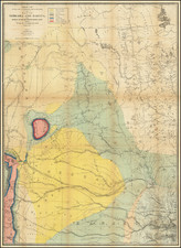
Unusual combination of Dakota & Nebraska. Hand colored by counties and showing railroads, towns, post offices, stations, Indian Reservations & Villages, Forts, etc. Very few counties in Dakota. Over a dozen American Forts on the Missouri and Platte River are noted with American Flags. From one of the leading American map publisher of the 1870s. The first time we have ever seen this map. From the true first edition of Gray's National Atlas.
O.W. Gray Biography
O. W. Gray was a publishing firm based in Philadelphia. Later, they published as O. W. Gray & Son. They published atlases in the late nineteenth century. Gray's National Atlas was one of the most successful commercial ventures of the 1870s and one of the last to employ hand coloring on maps.