|
||

|

|
|

|
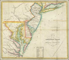
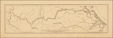
Drawn From The First Printed Map to Mention George Washington -- Carolina Shown West of North Carolina -- Virginia Extending to Lake Michigan
Scarce early map of the British Colonies in North America, one of the earliest maps of a portion of the British Colonies in North America to appear in a British serial publication.
The map shows the British Colonies extending to the Ohio River, a direct encroachment upon the claims of the French. The map provides a curious depiction of the Colonies, with boundary lines trending northward, rather than to the west, as would become the somewhat more standardized depiction following the publication of John Mitchell's map in 1755.
Among the more unusual features of the map is its inclusion of a second Carolina, far to the west of "N. Carolina". This is almost certainly a reference to the Carolana Grant of 1622, which had become significant again following Daniel Coxe's book of 1722 resurrecting the discussion of the validity of the claim. The Carolana Grant controversy seems to have been an issue in 1754 and 1755, as it appears on both Henry Overton's important broadside map (see below) and on Thomas Jeffery's influential North America from the French of Mr. D'Anville Improved with the Back Settlements of Virginia and Course of Ohio Illustrated with Geographical and Historical Remarks . . . May 1755
The present map is copied from Henry Overton's highly important broadside map of the same title, first published in 1754, which includes the first printed reference to George Washington. Printed in London by Henry Overton Jr., the broadside was intended to provide the British public with news of the recent skirmishes between the French and English in the American Colonies and inflame the English public to the reported French "depredations" in the Colonies. Curiously, the reference to George Washington is one of the details omitted from the present map.
As noted on page 122 of "Washington As Surveyor And Map-Maker" (Philip Lee Phillips, Chief, Division of Maps, Library of Congress) in Daughters of the American Revolution Magazine (Vol LV, No. 3, March 1921), pp 115-133:
The [map] "An accurate of the English Colonies in America, bordering on the River Ohio," measuring 13 1/2 by 18 1/2 inches with border, is the earliest literary production in which Washington is mentioned. Scanning the map you will find noted between the "Ohio or Bell River" and the "Monongohela R," the statement, "Here C. Washington engag'd ye French, 1754." The "C" evidently is an abbreviation of "Colonel." The map is bordered on each side by an historical statement in which Washington figures. . .
As noted by Phillips above, Overton's broadside map is the first printed map to show George Washington's name in print and the earliest printed reference to George Washington of any kind. A second state of the map was issued, with the title changed from "English Colonies" to "British Colonies" and minor changes to the text. The broadside is undated, but was almost certainly issued in the Fall of 1754.
The present maps is a reduced version of the map (without text at the sides or reference to Washington in the map itself), which was issued in the Universal Magazine in December, 1754.
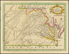
The Carolana Grant
The present map shows two Carolinas, one of which is considerably west of its correct location. The western name is almost certainly a reference to the Carolana Grant, originally granted on October 30, 1629, by King Charles I, to Sir Robert Heath, the King's Attorney General from 1625 to 1631, although the present usage would almost certainly reference the acquisition of the region by Daniel Coxes in 1696.
The original Carolana grant covered the territory between 31° and 36 ° North latitude, covering the areas from about thirty miles north of the Florida state line to the southern side of Albemarle Sound in North Carolina, essentially all of Georgia, the Carolinas, Mississippi, Alabama and Tennessee. The following year Sir Robert Heath conveyed this land to Samuel Vassall and others, who explored it, and made an ineffectual attempt to settle the area.
By 1632, Henry Lord Maltravers claimed the area as the Province of Carolana under an alleged grant from Heath and by the Harvey Patent issued by the Governor John Harvey of Virginia. The Harvey Patent established Maltravers' claim to the area south of the James River known as Norfolk County. No effective settlement was established, although between 1629 and 1640, there were numerous attempts by different parties to advance settlements in the Province of Carolana.
By November 1645, Robert Heath had been formally stripped of all of his possessions, in connection with the English Civil War. The pursuit of settlement of Carolana continued. Notably, several manuscript maps attributed to John Ferrar reference Carolana in the early 1650s.
In 1663, King Charles II granted a new charter to eight Lords Proprietors. Soon thereafter, Lord Maltravers' heirs, the Duke of Norfolk and Samuel Vassall, filed counter-claims, and the Cape Fear Company added its name to those contesting title by the new eight Lords Proprietors. On August, 1665, the Privy Council confirmed King Charles II's more recent grant and declared all previous grants to be null and void.
Despite the voiding of the grant, the grant by Sir Robert Heath to Lord Maltravers, et al., was later conveyed in 1678 to James Hays, by Henry Duke of Norfolk, and from Duke to Sir James Shaen, whose heir, Sir Arthur Shaen, conveyed the title in June 1696, to Dr. Daniel Coxe.
According to Cumming, the land Coxe claimed began at the western edge of Carolina and ran to the Mississippi River. Dr. Daniel Coxe (1640-1730) was a physician, natural philosopher and colonial adventurer, who served as the physician to King Charles II and Queen Anne. Before the Carolana Grant, Coxe purchased one million acres of land in west New Jersey in the mid-1680s and served nominally as its governor, although he never left England. After selling the bulk of his holdings to the West New Jersey Society of London in 1692, Coxe shifted his interests further south, acquiring title to the province of 'Carolana' from the heirs Sir James Shaen.
By 1698, Dr. Coxe had begun an aggressive campaign with the English Government to validate his claim to Carolana. In connection therewith, his plans for a settlement in the Mississippi Valley were set forth. Coxe entered into an agreement in May 1698, with Sir William Waller, Olivier de la Muce and Charles de Sailly, providing that the latter would create a colony in Carolana. The colony intended was a settlement of French Hugenot refugees, led by Charles de Sailly, the fourth of five such settlements undertaken by de Sailly. In October 1698, two ships were sent by Coxe and de Sailly, one of which successfully reached Charleston. From there, the settlers transferred to the Carolina Galley and left Charleston in 1699, rounded Florida, and reached the mouth of the Mississippi River, where they began the trip northward. On August 29, 1699, shortly after beginning to ascend the river, they encountered the French ship Renommee, commanded by Bienville. Bienville seized maps and documents from the expedition and forced it to turn back down river. The evidence of the English incursion up the Mississippi River was transferred back to Paris and forms yet another fascinating chapter in the life of Daniel Coxe.
Before the news of the Carolina Galley expedition returned to London, Coxe and his colleagues had turned their colonization interests to Jamaica and Norfolk County, Virginia, the latter of which had been a part of the Carolana grant which Coxe had pressed.
Later, the Coxe family laid claim to an enormous region in the south, based on royal grants received by Dr. Daniel Coxe, with the intention of forming a trading company to establish an English colony at the mouth of the Mississippi River. In 1722 his son Colonel Daniel Coxe published the first description of the region to further his family's claims. "Apparently to avoid conflict with the established settlements of the lords proprietors, only the country west of the settled portion of Carolana was claimed by Coxe" (Cumming). Beyond his own claims, Coxe published the work to raise awareness of the significant potential of the area and the dangers posed by French incursions.
In his Coxe's book, published in 1722, the younger Coxe describes the first English exploration of the Mississippi Valley and gives the first English account of Louisiana. He encourages settlement in this area in opposition to the parallel activities of the French, and distinctly seeks to expand English colonization away from the Atlantic coast. DAB further credits Coxe with being the first to publish a plan for the political union of the North American colonies.
![[ Bunker Hill ] A Plan of the Action at Bunkers Hill on the 17th of June 1775 between His Majesty's Troops, Under the Command of Major General Howe, and the American Forces . . .](https://storage.googleapis.com/raremaps/img/small/70223.jpg)