|
||

|

|
|

|
Stock# 83109
Description
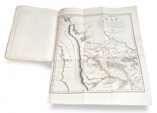
Striking map of the Great Lakes, Canada and Northeastern US, based upon Guillaume De L'Isle's map of 1703, which was then one of the most accurate and up to date maps of the Great Lakes region.
The map includes an excellent treatment of the Upper Mississippi and is extensively annotated. Also includes a decorative cartouche and compass rose. A number of early French Forts are shown.
A fascinating look at French America, on the eve of the French & Indian War.
![[ Northern Pacific Railroad ] NEW 7-30 GOLD LOAN OF THE Northern Pacific Railroad Co. SECURED BY FIRST MORTGAGE ON RAILROAD AND LAND GRANT. SAFE! PROFITABLE! PERMANENT!](https://storage.googleapis.com/raremaps/img/small/101828.jpg)