|
||

|

|
|

|
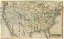
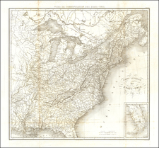
Striking full-color example of Homann's map of the Course of the Mississippi River. The map is notable for being based upon the reports of Louis Hennepin, the French Jesuit missionary who explored the upper Mississippi and Great Lakes regions in the late seventeenth century.
Homann’s “Louisiana Province” is one of the most attractive early maps of the American interior, as well as being politically provocative. The map illustrates the eastern half of the future United States, focusing on the region called “La Louisiane,” control of which was actively contested by Spain and France throughout the 1700s.
Homann’s maps is drawn from Guillaume De L'Isle’s seminal Carte de la Louisiane et du Cours du Mississipi of 1718. Delisle’s labeling of the territory west of the Appalachians as
La Louisiane assumed a French proprietorship that provoked angry protests from the Spanish and British governments. Homann repeated the label on the present map, thus
perpetuating a cartographic battle in which the mapmakers of each country issued publications showing their preferences toward political claims.
The map follows the geographical tendencies of the aforementioned de L'Isle map. The Mississippi is oddly misplotted, with the Ohio and several other tributaries splitting to the east and tracking near a decorative vignette showing Indians hunting long-horn buffalo in forested lands.
The western rivers, including the Missouri, are equally inaccurate. The Missouri terminates at the furthest pointed reached by Louis-Armand de Lahontan as part of his search along the "Riviere Longue" for a transcontinental route. Going southwards, The map shows a number of explorers’ routes throughout the southwest and Louisiana and annotations regarding various regions. Many Indian Tribes and early forts were named. Florida is an archipelago.
The map includes a very early form of the word Texas, seen in the legend reading "Mission de las Teyas, etablie en 1716" near present-day San Antonio. Other Texas-related detail is particularly embellished.
The title cartouche shows Father Hennepin with allegorical figures depicting his exploration of the New World. The vignette shows an early representation of an American bison flanked by Indians. This dedication is a reinforcement of French proprietorship of the Louisiana region.
This is, without a doubt, one of the most interesting and decorative regional maps of America from the period.
Johann Baptist Homann (1663-1724) was a mapmaker who founded the famous Homann Heirs publishing company. He lived his entire life in Bavaria, particularly in Nuremberg. Initially, Johann trained to become a priest before converting to Protestantism and working as a notary.
In 1702, Johann founded a publishing house that specialized in engravings. The firm flourished, becoming the leading map publisher in Germany and an important entity in the European map market. In 1715, Johann was named Imperial Geographer to the Holy Roman Empire by Charles VI and made a member of the Prussian Academy of Sciences. Most importantly for his business, his reputation and contacts gained him imperial printing privileges which protected his publications and recommended him to customers. Johann is best known for this Grosser Atlas ueber die ganze Welt, or the Grand Atlas of the World, published in 1716.
After Johann died in 1724, the business passed to his son, Christoph (1703-1730). Upon Christoph’s early death, the company passed to subsequent heirs, with the name of the company changing to Homann Erben, or Homann Heirs. The firm continued in business until 1848.