|
||

|

|
|

|
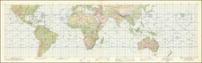
This chart, titled "Gemini Mission Chart (GMC) 7," was created in November 1965 by the United States Air Force Aeronautical Chart and Information Center and lithographed by ACIC. It served as an integral navigational tool for the Gemini 7 mission, detailing ground track coordinates, tracking station symbols, and planned landing zones across various oceanic regions.
In the mid-1960s, the Gemini Program marked a critical phase in the United States' space exploration efforts, paving the way for the more ambitious Apollo missions. The Gemini 7 mission, in particular, set the stage for extended human spaceflight, testing endurance and equipment in a long-duration orbit. This chart's detailed depiction of tracking stations, with their specific capabilities and ranges, as well as the planned landing zones in the Atlantic and Pacific, underscores the mission's complexity and the precision required in space navigation.
The document is rich in technical detail, outlining the capabilities of various tracking stations around the world, including types of radar and communication methods. Symbols and annotations provide a visual and textual guide to understanding the spacecraft's trajectory and operational parameters for each revolution, from the 17th through to the 210th. This illustrates the intricate choreography of ground support and spacecraft maneuvering inherent to space missions.
![[ Walking on the Moon -- Apollo 15 Extra Vehicular Activity Atlas ] Hadley-Apennine Landing Site Apollo 15 - 1:12,500 and 1:25,000](https://storage.googleapis.com/raremaps/img/small/68099.jpg)