|
||

|

|
|

|
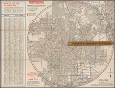
LANDSAT 7 Scene of the Greater Los Angeles Area, produced by the U.S. Geological Survey under the aegis of the U.S. Department of the Interior and in collaboration with NASA, is an authoritative satellite perspective of the Los Angeles Basin as of November 6, 2002. Composed on quality photo paper, this expansive color representation captures the intricate interplay of urban development and natural topography, encased within a defined black border and background.
The early 21st century was a time of both progress and challenges for the Greater Los Angeles Area. The city, long famed as a center for entertainment, culture, and commerce, was also grappling with issues of urban sprawl, environmental concerns, and infrastructural demands. Satellite imagery, such as this one from the LANDSAT 7, was instrumental in urban planning, environmental assessments, and scientific research. This particular image provides an unadulterated view from above, documenting the city in all its complexity.
LANDSAT 7
LANDSAT 7, launched on April 15, 1999, represents a significant advancement in the Landsat series of Earth observation satellites, which have been capturing images of our planet's surface since the early 1970s. Operated by the United States Geological Survey (USGS) and NASA, Landsat 7's primary instrument, the Enhanced Thematic Mapper Plus (ETM+), has been instrumental in capturing high-resolution, multispectral images that have been used in a myriad of scientific, agricultural, and environmental studies. These images have informed decisions related to land management, resource monitoring, and environmental change detection. Unfortunately, in 2003, the satellite experienced a hardware failure leading to the "scan line corrector" problem, resulting in a series of data gaps in its images. Nevertheless, Landsat 7 has been invaluable in providing consistent, long-term data that has furthered our understanding of the Earth's dynamic landscape.
![[ Los Angeles / Harris Newmark ] Newmark Block Junction of Main and Spring Sts., Los Angeles, Cal.](https://storage.googleapis.com/raremaps/img/small/97889.jpg)
![[ Orange County / Wine Industry ] Residence of Theodore Reiser, Anaheim, Los Angeles Co., Cal.](https://storage.googleapis.com/raremaps/img/small/96403.jpg)