


|
||

|

|
|

|
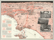
Rare folding map of Los Angeles and Vicinity, with riveted rotating pointer.
In the bustling era of the Roaring Twenties, the streets of Los Angeles were undergoing rapid transformation. The emergence of new roads, the expansion of street car and bus networks, and the growth of neighborhoods were emblematic of a city in flux.
The E-Z Guide Map is a scarce folding map encompassing Los Angeles and its vicinity. What sets this map apart from others of its time is a unique riveted rotating pointer, a novel tool designed to aid in navigation and bring a tangible interactivity to the cartographic experience. This edition of the map was interestingly crafted as a promotional tool for Security Trust & Savings Bank and included key locations of the bank's branches.
The map is visually and practically intriguing. Alongside general mapping information, it features Automobile routes, Interurban Railway (Rwy) Lines in red, and Railway Lines in black. This color-coding not only adds to the map's visual appeal but also enhances its usability, providing easy identification of different transport routes.
- Interurban Rwy Lines: Illustrated in red, these lines signified the local railway system that connected different urban areas within Los Angeles, an essential part of daily commuting for many residents.
- Railway Lines: Shown in black, these highlighted the broader railway lines that reached beyond the city, connecting Los Angeles to neighboring regions and states.
The E-Z Guide Map of Los Angeles is a snapshot of a dynamic and evolving city. It is a piece of history, capturing the zeitgeist of Los Angeles in 1924 - a time of innovation, expansion, and opportunity. Through its unique design features, including a riveted rotating pointer and distinct color-coded routes, it transcended the traditional function of a map, becoming an interactive guide and promotional tool.
![(Hollywood) [Annotated Real Estate Map of Hollywood]](https://storage.googleapis.com/raremaps/img/small/97362.jpg)

![[ NAACP Banquet - Los Angeles ] National Association for the Advancement of Colored People Human Rights Banquet Honoring Philip Murray -- Alexandria Hotel, Los Angeles, Calif - Jan 16, 1953](https://storage.googleapis.com/raremaps/img/small/99632.jpg)