|
||

|

|
|

|
Stock# 77041
Description
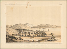
Wonderful and scarce pictorial map of Catalina Island, issued near the height of its early heyday as a vacation destination for Southern Californians.
The map shows the island, with characters participating in the various activities to be found there. An arrow and note indicate "Where the Great Catalina Channel Swim started Jan 15 1927". There are 24 points of interest noted in a key. And perhaps most tantalizingly the sites of five prehistoric Indian villages are noted.
The map was put out in 1927 to promote the offerings of the Wilmington Transportation Company, operating routes from Long Beach to Catalina.
Condition Description
Folding pamphlet map, printed on both sides.