|
||

|

|
|

|
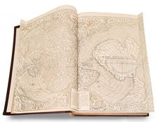
Fine pair of large maps of the eastern and western hemispheres, published in 1797 in Nuremberg by Schneider and Weigel, crediting the mapmaker as simply as "S.....n" (Daniel Friedrich Sotzmann).
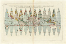
As noted in the title, the map is based upon Aaron Arrowsmith's monumental Map of the World on a Globular Projection, first issued in London in 1794.
Sotzmann's world map relies upon Arrowsmith for a meticulous amalgamation of scientific discovery and cartographic precision, significantly commemorating the nautical explorations of Captain James Cook, including an early depiction of the Hawaiian Islands
One of the more fascinating elements of the map is its potential connection to the so-called Ebeling-Sotzmann Atlas of America. In the margin at the left of the western hemisphere is a detailed list of the different United States, as well as parts of Mexico, Central America and South America. At the right side is an extensive list of abbreviations and a note regarding the Papal Demarcation, Line of the Portuguese and Spanish territories in South America according to the Partition Treaty of Ildefonso in 1777 and its confirmation by the Peace Treaty of Pardo in 1778. No similar notes appear in the eastern hemisphere.
In the late 15th and early 16th centuries, as Portugal and Spain explored the New World, they sought the Papacy's guidance to resolve territorial disputes. The most famous demarcation came with the Treaty of Tordesillas in 1494, which was sanctioned by Pope Julius II. This treaty divided the newly discovered lands outside Europe between Portugal and Spain along a meridian 370 leagues west of the Cape Verde islands (off the west coast of Africa). This division was intended to resolve disputes over newly discovered lands without resorting to war.
However, the text references the Treaty of Ildefonso in 1777 and its confirmation by the Peace Treaty of Pardo in 1778. These treaties, coming much later, were between Spain and Portugal and aimed to settle disputes about territories in South America, especially regarding the border between Spanish-held territories and the Portuguese colony of Brazil. The Treaty of San Ildefonso (1777) was specifically about the borders in the Rio de la Plata basin between Spanish and Portuguese territories. The Treaty of El Pardo (1778) confirmed and adjusted the provisions of the earlier treaty.
Sotzmann had worked for a number of years with Christoph Daniel Ebeling, a professor of history and classical languages in Hamburg. In the 1770s, Ebeling began gathering data for a massive geography and history of the United States. His first published work was Amerikanische Bibliothek. He also corresponded with many important Colonial and US colleagues, thereby assembling one of the best Americana libraries of the time. His Erdbeschribung und Geschichte von Amerika, die vereinten Staaten von Amerika, was a multi-volume work, the first volume of which was published in 1793. Over the next 25 years, he published six additional volumes, the last of which was issued in 1816. The work was interrupted by his death in 1817.
In 1795, Ebeling recognized the need for an Atlas volume and began compiling his Atlas von Norkamerika. The plan was for 18 maps, 16 of which would be separate states. Of the 18 maps, only 10 are known to have been issued and there are only a handful of complete sets known.
Beyond the United States, Sotzmann is known to have created a number of other maps which fit into the ruberic of a wider atlas of America. This world map is certainly consistent with that broader theme.
States of the Map and Rarity
The map is known in at least 2 states, 1797 and 1805.
The map is rare on the market, especially as a pair in the first state.
![Planisphere Physique ou l'on voit du Pole Septentrional ce que l'on connoit de Terres et de Mers Avec les Grandges Chaines de Montagnes . . . [Bay or Sea of the West]](https://storage.googleapis.com/raremaps/img/small/98378.jpg)
![Ленин – вождь международного пролетариата [Lenin – Leader of the International Proletariat]](https://storage.googleapis.com/raremaps/img/small/93242.jpg)
![[Map of the World on a Globular Projection Exhibiting Particularly the Nautical Researches of Capn. James Cook, F.R.S. with all the Recent Discoveries to the Present Time carefully Drawn by A. Arrowsmith . . . ]](https://storage.googleapis.com/raremaps/img/small/94140.jpg)