


|
||

|

|
|

|
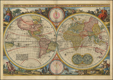
This 1808 edition of Aaron Arrowsmith's double hemisphere world map is a meticulous amalgamation of scientific discovery and cartographic precision, significantly commemorating the nautical explorations of Captain James Cook. Known for its instrumental role in establishing Arrowsmith's reputation in the London trade, this map embodies a notable milestone in the evolution of English cartography.
The map, first issued in 1794, emerged during a period of fervent global exploration, marked by significant advancements in cartography and navigational technologies. The late 18th and early 19th centuries were a time when the world's geography was being progressively understood and documented. Arrowsmith's map reflects this exploratory spirit, portraying the world with a scientific exactitude hitherto unseen in wall maps, a testament to the era's strides in geographical understanding.
This "Map of the World on a Globular Projection" not only charts geographical territories but also narrates the journeys of some of the era's most noteworthy explorers. It traces the path of Captain James Cook's voyages, thereby encapsulating the global impact of Cook's explorations, from the Pacific Islands to the icy realms of the Antarctic. It also includes the discoveries of other circumnavigators and explorers, such as Mackenzie and Hearne's ventures in the Canadian Arctic, providing a comprehensive overview of the global explorations of the time.
The 1808 edition stands out for its significant revisions to the depiction of Western North America. The speculative information from previous versions was removed, resulting in a more precise portrayal of the Rocky Mountains and the upper Missouri River. Additionally, the far western Canada region was redrawn, likely based on Mackenzie's discoveries. These adjustments reflect Arrowsmith's commitment to accuracy and the evolving understanding of North American geography.
In essence, Arrowsmith's "Map of the World on a Globular Projection" is a historical document of immense value, encapsulating a transformative period in global exploration and cartography. Its portrayal of the world, accentuated by the tracks of renowned explorers, makes it a significant record of the scientific and geographical knowledge of the early 19th century. Its revisions and improvements over time, particularly in the depiction of North America, further affirm its standing as a dynamic artifact of evolving geographical comprehension.
Dating The Map
Because not all examples of the map include the title and dating information, which were printed on separate sheets and are frequently lacking, dating the map has created confusion. A number of institutional examples are misdated or otherwise cataloged in a misleading fashion.
In Comparative Cartography (91) Stevens & Tree note four states of the map (1794, 1799, 1808, and 1814). In reality, there are at least seven states:
- 1794. Boston Public Library.
- 1799. John Carter Brown Library.
Lacking Bass Strait. - 1799. Stanford, Rumsey Center. Eastern Hemisphere. Western.
Naming Bass Strait. (Bass Strait was reported to the Admiralty in 1799.) - 1808. The present example.
Western North America heavily revised, removing much speculative information and redrawing the Rocky Mountains and upper Missouri River.
Far western Canada redrawn, probably after Mackenzie. - 1808 (1811) - Stanford. Rumsey Center.
Northern coasts of Japan (Hondius and especially Hokkaido) revised. Arrowsmith is now described as "...Hydrographer to H.R.H. the Prince of Wales." - 1814. MacLean Collection.
"D.o___1814" - 1818. MacLean Collection.
"D.o___1818"
The Arrowsmiths were a cartographic dynasty which operated from the late-eighteenth century to the mid-nineteenth. The family business was founded by Aaron Arrowsmith (1750-1823), who was renowned for carefully prepared and meticulously updated maps, globes, and charts. He created many maps that covered multiple sheets and which were massive in total size. His spare yet exacting style was recognized around the world and mapmakers from other countries, especially the young country of the United States, sought his maps and charts as exemplars for their own work.
Aaron Arrowsmith was born in County Durham in 1750. He came to London for work around 1770, where he found employment as a surveyor for the city’s mapmakers. By 1790, he had set up his own shop which specialized in general charts. Arrowsmith had five premises in his career, most of which were located on or near Soho Square, a neighborhood the led him to rub shoulders with the likes of Joseph Banks, the naturalist, and Matthew Flinders, the hydrographer.
Through his business ties and employment at the Hydrographic Office, Arrowsmith made other important relationships with Alexander Dalrymple, the Hudson’s Bay Company, and others entities. In 1810 he became Hydrographer to the Prince of Wales and, in 1820, Hydrographer to the King.
Aaron Arrowsmith died in 1823, whereby the business and title of Hydrographer to the King passed to his sons, Aaron and Samuel, and, later, his nephew, John. Aaron Jr. (1802-1854) was a founder member of the Royal Geographical Society (RGS) and left the family business in 1832; instead, he enrolled at Oxford to study to become a minister. Samuel (1805-1839) joined Aaron as a partner in the business and they traded together until Aaron left for the ministry. Samuel died at age 34 in 1839; his brother presided over his funeral. The remaining stock and copper plates were bought at auction by John Arrowsmith, their cousin.
John (1790-1873) operated his own independent business after his uncle, Aaron Arrowsmith Sr., died. After 1839, John moved into the Soho premises of his uncle and cousins. John enjoyed considerable recognition in the geography and exploration community. Like Aaron Jr., John was a founder member of the RGS and would serve as its unofficial cartographer for 43 years. Several geographical features in Australia and Canada are named after him. He carried the title Hydrographer to Queen Victoria. He died in 1873 and the majority of his stock was eventually bought by Edward Stanford, who co-founded Stanford’s map shop, which is still open in Covent Garden, London today.
![Western Hemisphere. Eastern Hemisphere. [showin the Republic of Texas]](https://storage.googleapis.com/raremaps/img/small/82886.jpg)