|
||

|

|
|

|
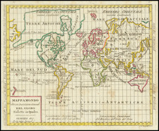
Dynamic Set of Globe Gores Showing California as an Island
Fine example of Heinrich Scherer’s globe gores (with additional sheet to be cut out to use on the globe furniture), included in his eight-volume atlas of 1703. The world map includes California as an island and a hypothetical depiction of Australia.
The twelve globe gores depict the world centered on the Atlantic Ocean. North America is stretched east-to-west in the north, a typical depiction for the time. A Northwest Passage is suggested, as open water flows around the Arctic waters into the Pacific. There is also an open river flowing into the interior of the continent, suggesting an interior passage as well. California is separated from the continent as an island, again a common depiction for the time (see below).
Tierra del Fuego, at the tip of South America, is shown in a curious way. The lands of Patagonia are exaggerated in the southwestern portion of the continent. The Straits of Magellan, first navigated by Ferdinand Magellan in 1520, are shown. Tierra del Fuego is not labeled as due south of the Straits, but as to the east of it, where Staten Land usually is shown on other maps.
Staten Land was discovered when a Dutch voyage, led by Schouten and Lemaire, sought to find an alternative route to the Pacific than the Straits of Magellan. The Straits had been claimed for the sole use of the Dutch East India Company, shutting out other merchants. Schouten and Lemaire angled their expedition between Staten Land and the continent, which led their ships around blustery Cape Horn.
In Asia, the north of Japan is large and bulbous, labeled as “T. Iedso.” Iedso is a reference to Jesso, a feature included on many seventeenth and eighteenth-century maps. Historically, Eso (Yeco, Jesso, Yedso, Yesso) refers to the island of Hokkaido. It varies on maps from a small island to a near-continent sized mass that stretched from Asia to Alaska.
Farther south, New Holland, or Australia, is outlined. The Dutch had been encountering western Australia for a century by the time this map was made, but western Australia remained a mystery to Europeans until the late eighteenth century; here eastern Australia is left open and blank to show this ambiguity. Farther east, the western edge of New Zealand is shown. This was contacted by Abel Tasman in the 1640s, but would not be seen again by Europeans until Captain Cook’s first voyage, which set out in 1768.
The popular misconception of California as an island can be found on European maps from the sixteenth through the eighteenth centuries. From its first portrayal on a printed map by Diego Gutiérrez, in 1562, California was shown as part of North America by mapmakers, including Gerardus Mercator and Abraham Ortelius. In the 1620s, however, it began to appear as an island in several sources. While most of these show the equivalent of the modern state of California separated from the continent, others, like a manuscript chart by Joao Teixeira Albernaz I (ca. 1632) now in the collection of the National Library of Brasil shows the entire western half of North Americas as an island.
The myth of California as an island was most likely the result of the travel account of Sebastian Vizcaino, who had been sent north up the shore of California in 1602. A Carmelite friar, Fray Antonio de la Ascensión, accompanied him. Ascension described the land as an island and around 1620 sketched maps to that effect. Normally, this information would have been reviewed and locked in the Spanish repository, the Casa de la Contratación. However, the manuscript maps were intercepted in the Atlantic by the Dutch, who took them to Amsterdam where they began to circulate. Ascensión also published descriptions of the insular geography in Juan Torquemada’s Monarquia Indiana (1613) (with the island details curtailed somewhat) and in his own Relación breve of ca. 1620.
The first known maps to show California as an island were on the title pages of Antonio de Herrera’s Descripción de las Indias Occidentales (1622) and Jacob le Maire's Spieghel Der Australische Navigatie (1622). Two early examples of larger maps are those by Abraham Goos (1624) and another by Henry Briggs, which was included in Samuel Purchas’ Hakluytus Posthumus or Purchas his Pilgrimes (1625). In addition to Briggs and Goos, prominent practitioners like Jan Jansson and Nicolas Sanson adopted the new island and the practice became commonplace. John Speed’s map (1626-7), based on Briggs’ work, is well known for being one of the first to depict an insular California.
The island of California became a fixture on mid- and late-seventeenth century maps. The island suggested possible links to the Northwest Passage, with rivers in the North American interior supposedly connecting to the sea between California and the mainland. Furthermore, Francis Drake had landed in northern California on his circumnavigation (1577-80) and an insular California suggested that Spanish power in the area could be questioned.
Not everyone was convinced, however. Father Eusebio Kino, after extensive travels in what is now California, Arizona, and northern Mexico concluded that the island was actually a peninsula and published a map refuting the claim (Paris, 1705). Another skeptic was Guillaume De L’Isle. In 1700, De L’Isle discussed “whether California is an Island or a part of the continent” with J. D. Cassini; the letter was published in 1715. After reviewing all the literature available to him in Paris, De L’Isle concluded that the evidence supporting an insular California was not trustworthy. He also cited more recent explorations by the Jesuits (including Kino) that disproved the island theory. Later, in his map of 1722 (Carte d’Amerique dressee pour l’usage du Roy), De L’Isle would abandon the island theory entirely.
Despite Kino’s and De L’Isle’s work, California as an island remained common on maps until the mid-eighteenth century. De L’Isle’s son-in-law, Philippe Buache, for example, remained an adherent of the island depiction for some time. Another believer was Herman Moll, who reported that California was unequivocally an island, for he had had sailors in his offices that claimed to have circumnavigated it. In the face of such skepticism, the King of Spain, Ferdinand VII, had to issue a decree in 1747 proclaiming California to be a peninsula connected to North America; the geographic chimera, no matter how appealing, was not to be suffered any longer, although a few final maps were printed with the lingering island.
![[Early Photographic Facsimile of the 1529 Ribero World Map]](https://storage.googleapis.com/raremaps/img/small/67279.jpg)

![De Schepping der Wereldt Volgens de Beschryving van Mozes. 1 Plaat [in set with] De Schepping der Wereldt Volgens de Beschryving van Mozes. 2. Plaat](https://storage.googleapis.com/raremaps/img/small/102641.jpg)