|
||

|

|
|

|
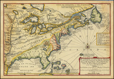
Striking map of the United States and Canada, apparently issued in a very late edition of Zatta's Atlante Novissimo, first issued in 1778. The map has been substantially updated, although the geopolitical border of the US States are a bit curious. Included among the states and territories are Cherachesia , Alta and Bassa Luigiana Inglese and a massive projection of Ohion, extending to the Mississippi River, one of the only known maps to so exagerate Ohio's boundaries. The map retains an odd projection of the Great Lakes which is now at least 40 years outdated. Florida is shown as an oddly shaped archipelago, again a very late and unusual variant of this misconception.
Antonio Zatta (fl. 1757-1797) was a prominent Italian editor, cartographer, and publisher. Little is known about his life beyond his many surviving published works. It is possible that he was born as early as 1722 and lived as late as 1804. He lived in Venice and his work flourished between 1757 and 1797. He is best known for his atlas, Atlante Novissimo (1779-1785), and for his prolific output of prints and books that were both precisely made and aesthetically pleasing. Zatta clearly had a large network from which to draw information; this is how he was able to publish the first glimpse of the islands visited by Captain Cook in the Atlante Novissimo. Zatta also published books of plays and architecture.