


|
||

|

|
|

|
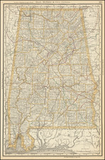
The Most Important Map of the State of Alabama From the 19th Century.
Impressive and exceedingly rare map of Alabama and West Florida, produced by one of the greatest Southern map makers, John La Tourette. Here reissued in 1856 by D. H. Cram in Montgomery, this map was considered of such importance that the Alabama legislature ordered copies of this edition for each state and territory in the union, as well as the probate judges of every Alabama county at the impressive price of ten dollars apiece.
The map is a masterpiece of Alabama cartography and was the map of record for the era. This map, rare as it is, is often used as a valuable primary source for researchers and has been cited as providing locations and information otherwise not available. The map was copied in reduced editions by most New York and northern mapmakers for their maps of the state.
The map was compiled from original surveys by La Tourette, who derived the map directly from township surveys held in each of the five land offices in the state. As such, the map is divided into townships and sections. In addition, rivers, mountains, roads, and much more are shown. Annotations describe important features and historical points of interest such as battle sites or Native American treaty boundaries.
John La Tourette was an important early Alabama cartographer who worked out of Mobile, which was then the cartographic hub of the state. He had moved to Mobile sometime prior to 1830, having been born in New York in 1785 and there educated. The map was engraved by George Sherman, and this edition was issued by D. H. Colton in Montgomery.
D. H. Cram purchased the plates of the map directly from La Tourette prior to the publication of the map. He had served in the Mexican-American War, where he had served in the campaign against Mexico City and was wounded at Contreras. He then became a civil engineer based in New England and worked for the railroads in the South. Just after the publication of this map, in 1856, he was appointed as superintendent of the railroads, and in 1858 he was appointed chief engineer and general superintendent. He would then become president of the Pensacola and Louisville railroad in 1870.
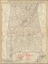
Manuscript Railroad Information and the Founding of Birmingham
This example of the map includes pencil annotations showing connections between various cities. The annotations relate most heavily to the region surrounding Elyton, where a number of newly-drawn railroad lines intersect. The Alabama Great Southern Railroad, which appears to be the first railroad to stop in Elyton, was approved in 1856 and would have been completed soon after. The lack of the annotation of the Mobile-Pensacola-Jackson Railroad, constructed in 1871, may provide dating for the manuscript annotations, or it may be an oversight.
The arrival of the railroads in Elyton was a defining moment in the industrialization of Alabama. The predecessor to Birmingham, which would incorporate Elyton in the early 20th century, the city's importance comes from the fact that it was the only place in the world that had significant amounts of minable coal, limestone, and steel close together. The Elyton Land Company, which founded Birmingham at the site of the railroad crossings, heavily advertised this and turned the region into one of the most industrialized parts of the US and the start of the New South.
States
This is the fourth and final recorded state of the map. The map had previously been issued in 1835, 1837, and 1838 by La Tourette under the name An Accurate Map of the State of Alabama and West Florida. . ., and this state shows significant updates. Among these are:
- The county structure is changed completely, with the density of counties increasing throughout. Numerous roads are added, particularly in the more rural parts of the state.
- Coal beds are marked throughout St. Clair County, as are a number of other mineralogical sites throughout the state.
- Substantial railroad information is added. This is apparent on the main map, where no previous railroads were shown, and railroads start to crisscross the state. Railroad depots are now shown on all the city maps. A cross-section of the elevation along the Mobile & Ohio, Alabama & Florida, and Alabama & Tennessee Rivers Railroads is provided.
- The vignette of the Capitol at Montgomery in the upper left replaces a view of the State House at Tuscaloosa. The Montgomery state capitol had been completed in 1851, just prior to the making of this map. The first Montgomery capitol building had been destroyed by a fire in 1849, and the building would soon become the first Confederate capital.
- The map of Florence shows the "College" building, which is now the University of North Alabama. Founded in La Grange, it had just moved to Florence and would soon become the first state-supported teacher's college in the South. Other expansions are shown, with residences of important early inhabitants shown.
- The state census is updated to a more readable format. Of particular interest, and predating the national fascination in the subject of eugenics, is the enumeration of "Insane within the county" and "Insane sent abroad."
Rarity
OCLC locates no examples of the 1856, though we believe there is an example at the Library of Congress that was reproduced in 1983. There are entries for the 1856 at the University of Alabama, but all of these are later reproductions. No examples of this state have appeared on Rare Book Hub and we have not seen any previously on the market.
Provenance
Western Reserve Historical Society
Despite his extremely important role in the early mapping of the American South, John La Tourrette (1785? - February 14, 1851) remains an enigmatic figure with only the scantest biographical details available. He was likely born in Staten Island, New York, to James La Tourrette Sr. (died 1796), but moved in the 1820s to the Center Port, Alabama area, becoming one of the first settlers in the region.
The Census of 1830 records a John La Tourrette of Mobile, Alabama, aged between 40 and 49 years old, some sources say 45.
Later, he moved to New Orleans (one source says in 1845), where he continued in his career as a mapmaker.
According to the inventory of his estate (digitized on Ancestry.com), La Tourrette died intestate on or about February 14, 1851, while living in New Orleans. When he died, La Tourrette had a considerable inventory of maps, mostly his own, which are enumerated in the court-ordered inventory. We quote liberally:
1. One Hundred and Fifty Two Large Maps of the State of Alabama, valued by the Said Appraisers at four Dollar each, say Six Hundred and Eight Dollars.
2. Twenty Seven large maps of the State of Mississippi, valued by the said appraisers at five Dollans each, say One Hundred and thirty five Dollars.
3. One Hundred and One large maps of the State of Louisiana, Valued by the said appraisers at Five Dollars each, Say, Five Hundred and Five Dollars;
4. One large map of the United States by the Said appraisers at Four Dollars,
5. One Map of the World, Valued by the Said Appraisers at Two Dollars,
6. Two Hundred Eighty two small maps of the State of Alabama, Valued by the Said appraisers at One Dollar each, Say, Two hundred and Eighty Two Dollars.
7. One Hundred and five Small Maps of the State of Mississippi, Valued by the Said appraisers at one Dollar each, say, One Hundred and five Dollars,
8. Three Maps of the City of New Orleans, unframed, Valued in lump, by the Said appraisers at Three Dollars,
9. One Hundred and Eighty nine maps of the City of Mobile, Valued by the Said appraisers at One Dollar each, Say, One Hundred and Eighty nine Dollars,
10. Ten Maps of the Choctaws Lands, Valued by the said appraisers at One Dollar each, Say, Ten Dollars,
11. Two Boxes of Sundry unframed maps, Books, Portions of Plans +s, Vlaued in Lump by the Said appraisers at fifteen Dollars,
12. One Box of detached maps, small size, valued by said appraisers at Four Dollars
13. One Bundle of Maps Rolls, valued b the said appraisers at two Dollars,
14. Ten tin maps Cases, Valued by the said appraisers at fifty Cents each, say Five Dollars,
15. One Lot of Old [Harness?], Valued in lump by the said appraisers at Three Dollars,
16. One Lot of Tripoli, Valued by the said Appraisers in Lump at Five Dollars,
Together, the total Sum of One Thousand Eight Hundred and Seventy Seven Dollars.
And it being now half past Six O'clock P.M. and there being nothing else in Said Store belonging to the Estate of the Said Deceased further to be inventoried and appraised. . .
On May 11, 1851, The Times-Picayune advertised the sale of the La Tourrette estate inventory:
SALE OF MAPS.- We are requested to call attention to the succession sale of John La Tourrette, deceased, to take place at Banks's Arcade, to-morrow, Monday, at 12 o'clock. The articles for sale consist of Mr. Le Tourrette's maps of Louisiana, enlarged and improved, up to 1850, also of Alabama and Mississippi.
Writing in The Montgomery Advertiser, on August 16, 1936, Peter A. Brannon says of La Tourrette:
Alabama's original cartographer was a young man (that is, he is always referred to as such) and, I believe he originally resided in Alabama, in the vicinity of Cahaba. He may have been selected by Gov. Israel Pickens on account of his proximity to the statehouse at Cahaba. The name is pronounced "Lat-two-ret," although practically all early references are to La (Lar) tour-rette." Mr. Latourrette's maps are all inscribed with his residence at Mobile. It is known that people of his name were from Richmond, on Long Island, N. Y., and they moved to a point in Dallas County, east of and not far from Cahaba, about the time of the admission of the State into the Union [i.e., December 14, 1819]. One John LaTourrette, either a son or a nephew of the cartographer, is buried just outside the enclosure of the Episcopal Cemetery at Carlowville. I have been told that this man was a sleepwalker and entered the open window of a home in that village, and, by mistake, was killed as a burglar. The monument on his grave is an old-style table-slab marked. Some years ago I had the honor of the friendship of an old lady, then well beyond the four score milestone, who told me of her visits to the LaTourrette family on Long Island. [. . .]
As a private enterprise, Mr. LaTourrette published a map of Mobile dated 1838. Like many others issued for that city it seems to have been an excellent one though not officially adopted. Mobile adopted the DeLage map in 1837, this being published in '38 and it is not unlikely that the two men were competitors for official recognition.
I have never been able to learn much of John LaTourrette himself. Should this paper fall under the eye of one who can tell me of him, I will welcome the message.
The first printed record of La Tourrette's intention to publish a map appears in late 1831, when a long prospectus for "A New Map of Alabama" appeared in the Alabama State Intelligencer.
La Tourrette's cartographic output includes the following maps:
-
A Map Of The Choctaw Territory In Alabama From The United States Surveys Shewing Each Section & Fractional Section By John La Tourrette. . . (1833)
-
A Map of the Creek Territory in Alabama, from the United States Surveys, Shewing each Section & Fractional Section; By John La Tourrette, Mobile, Ala. . . . (1833)
-
La Tourrette's Map of the State of Alabama and West Florida: Carefully compiled from the original surveys of the General Government: revised corrected and published with he approval of the Governor and other State Officers. (1835, 1837, 1838, 1856)
-
[Privately-printed map of Mobile, Alabama, per Brannon] (1838)
-
An accurate map or delineation of Mississippi with a large portion of Louisiana & Alabama: showing the communication by land and water between the cities of New Orleans and Mobile, carefully reduced from the original surveys of the United States, being laid off into Congressional townships, and divided into mile squares or sections, on the plan adopted by the General Government for surveying public lands; so that persons may point to the tract on which they live. Compiled & Published by John La Tourrette, Mobile, Alabama, A.D. (1839, 1845, 1847)
-
Map of the State of Alabama Carefully compiled from the original Surveys of the General Government: and Published by John La Tourrette Mobile Ala. (1844)
-
La Tourrette's Reference Map of the State of Louisiana From The Original Surveys of the United States Which show the Spanish Grants, Townships, Sections, or mile squares, Settlement Rights &c. Also The Plantations With the owners names Engraved thereon. Compiled and Published by John La Tourrettte, New Orlean, LA. (1846, 1848, 1850?, 1853)
![[Florida and Gulf Coast] The Coast of West Florida and Louisiana . . . [with] The Peninsula and Gulf of Florida or Channel of Bahama with the Bahama Islands . . .](https://storage.googleapis.com/raremaps/img/small/66344.jpg)
![[ French Louisiana ] Carte De la Louisiane par Le Sr. D'Anville Dressee en Mai 1732. Publiee en 1752](https://storage.googleapis.com/raremaps/img/small/88804.jpg)