Search
Despite his extremely important role in the early mapping of the American South, John La Tourrette (1785? - February 14, 1851) remains an enigmatic figure with only the scantest biographical details available. He was likely born in Staten Island, New York, to James La Tourrette Sr. (died 1796), but moved in the 1820s to the Center Port, Alabama area, becoming one of the first settlers in the region.
The Census of 1830 records a John La Tourrette of Mobile, Alabama, aged between 40 and 49 years old, some sources say 45.
Later, he moved to New Orleans (one source says in 1845), where he continued in his career as a mapmaker.
According to the inventory of his estate (digitized on Ancestry.com), La Tourrette died intestate on or about February 14, 1851, while living in New Orleans. When he died, La Tourrette had a considerable inventory of maps, mostly his own, which are enumerated in the court-ordered inventory. We quote liberally:
1. One Hundred and Fifty Two Large Maps of the State of Alabama, valued by the Said Appraisers at four Dollar each, say Six Hundred and Eight Dollars.
2. Twenty Seven large maps of the State of Mississippi, valued by the said appraisers at five Dollans each, say One Hundred and thirty five Dollars.
3. One Hundred and One large maps of the State of Louisiana, Valued by the said appraisers at Five Dollars each, Say, Five Hundred and Five Dollars;
4. One large map of the United States by the Said appraisers at Four Dollars,
5. One Map of the World, Valued by the Said Appraisers at Two Dollars,
6. Two Hundred Eighty two small maps of the State of Alabama, Valued by the Said appraisers at One Dollar each, Say, Two hundred and Eighty Two Dollars.
7. One Hundred and five Small Maps of the State of Mississippi, Valued by the Said appraisers at one Dollar each, say, One Hundred and five Dollars,
8. Three Maps of the City of New Orleans, unframed, Valued in lump, by the Said appraisers at Three Dollars,
9. One Hundred and Eighty nine maps of the City of Mobile, Valued by the Said appraisers at One Dollar each, Say, One Hundred and Eighty nine Dollars,
10. Ten Maps of the Choctaws Lands, Valued by the said appraisers at One Dollar each, Say, Ten Dollars,
11. Two Boxes of Sundry unframed maps, Books, Portions of Plans +s, Vlaued in Lump by the Said appraisers at fifteen Dollars,
12. One Box of detached maps, small size, valued by said appraisers at Four Dollars
13. One Bundle of Maps Rolls, valued b the said appraisers at two Dollars,
14. Ten tin maps Cases, Valued by the said appraisers at fifty Cents each, say Five Dollars,
15. One Lot of Old [Harness?], Valued in lump by the said appraisers at Three Dollars,
16. One Lot of Tripoli, Valued by the said Appraisers in Lump at Five Dollars,
Together, the total Sum of One Thousand Eight Hundred and Seventy Seven Dollars.
And it being now half past Six O'clock P.M. and there being nothing else in Said Store belonging to the Estate of the Said Deceased further to be inventoried and appraised. . .
On May 11, 1851, The Times-Picayune advertised the sale of the La Tourrette estate inventory:
SALE OF MAPS.- We are requested to call attention to the succession sale of John La Tourrette, deceased, to take place at Banks's Arcade, to-morrow, Monday, at 12 o'clock. The articles for sale consist of Mr. Le Tourrette's maps of Louisiana, enlarged and improved, up to 1850, also of Alabama and Mississippi.
Writing in The Montgomery Advertiser, on August 16, 1936, Peter A. Brannon says of La Tourrette:
Alabama's original cartographer was a young man (that is, he is always referred to as such) and, I believe he originally resided in Alabama, in the vicinity of Cahaba. He may have been selected by Gov. Israel Pickens on account of his proximity to the statehouse at Cahaba. The name is pronounced "Lat-two-ret," although practically all early references are to La (Lar) tour-rette." Mr. Latourrette's maps are all inscribed with his residence at Mobile. It is known that people of his name were from Richmond, on Long Island, N. Y., and they moved to a point in Dallas County, east of and not far from Cahaba, about the time of the admission of the State into the Union [i.e., December 14, 1819]. One John LaTourrette, either a son or a nephew of the cartographer, is buried just outside the enclosure of the Episcopal Cemetery at Carlowville. I have been told that this man was a sleepwalker and entered the open window of a home in that village, and, by mistake, was killed as a burglar. The monument on his grave is an old-style table-slab marked. Some years ago I had the honor of the friendship of an old lady, then well beyond the four score milestone, who told me of her visits to the LaTourrette family on Long Island. [. . .]
As a private enterprise, Mr. LaTourrette published a map of Mobile dated 1838. Like many others issued for that city it seems to have been an excellent one though not officially adopted. Mobile adopted the DeLage map in 1837, this being published in '38 and it is not unlikely that the two men were competitors for official recognition.
I have never been able to learn much of John LaTourrette himself. Should this paper fall under the eye of one who can tell me of him, I will welcome the message.
The first printed record of La Tourrette's intention to publish a map appears in late 1831, when a long prospectus for "A New Map of Alabama" appeared in the Alabama State Intelligencer.
La Tourrette's cartographic output includes the following maps:
-
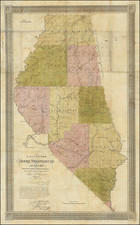
A Map Of The Choctaw Territory In Alabama From The United States Surveys Shewing Each Section & Fractional Section By John La Tourrette. . . (1833)
-
A Map of the Creek Territory in Alabama, from the United States Surveys, Shewing each Section & Fractional Section; By John La Tourrette, Mobile, Ala. . . . (1833)
-
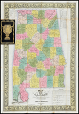
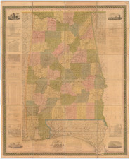
La Tourrette's Map of the State of Alabama and West Florida: Carefully compiled from the original surveys of the General Government: revised corrected and published with he approval of the Governor and other State Officers. (1835, 1837, 1838, 1856)
-
[Privately-printed map of Mobile, Alabama, per Brannon] (1838)
-
An accurate map or delineation of Mississippi with a large portion of Louisiana & Alabama: showing the communication by land and water between the cities of New Orleans and Mobile, carefully reduced from the original surveys of the United States, being laid off into Congressional townships, and divided into mile squares or sections, on the plan adopted by the General Government for surveying public lands; so that persons may point to the tract on which they live. Compiled & Published by John La Tourrette, Mobile, Alabama, A.D. (1839, 1845, 1847)
-
Map of the State of Alabama Carefully compiled from the original Surveys of the General Government: and Published by John La Tourrette Mobile Ala. (1844)
-
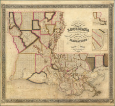
La Tourrette's Reference Map of the State of Louisiana From The Original Surveys of the United States Which show the Spanish Grants, Townships, Sections, or mile squares, Settlement Rights &c. Also The Plantations With the owners names Engraved thereon. Compiled and Published by John La Tourrettte, New Orlean, LA. (1846, 1848, 1850?, 1853)
Archived