


|
||

|

|
|

|
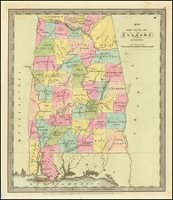
Fine example of Jean Alexandre Buchon's French-language edition of Carey and Lea's sought-after map of Alabama.
The map shows early roads, rivers, towns, bays, courthouses, and other early details. General Jackson's route to New Orleans and the Government road Nashville to Natchez are shown. Early forts are shown and the west still reflects several areas reserved to the Indians, as does the massive Upper Creek region in the east. West Florida is still not yet part of the United States.
Text on the sides of the map extensively describes the history, geography, and demographics of the state. The two first governors of the state are named. A chart tabulates the populations of each county, dividing according to white, freed blacks, and slaves. Some counties, which otherwise have among the highest proportions of slaves, have no freedmen.
The French edition of the Carey and Lea is known for being a superior work, using better paper and a superior engraving technique.
Jean Alexandre Buchon (1791-1849) was a French scholar and historian. Born as the French Revolution raged, Buchon was dedicated to recovering France’s history in order to help the country heal and grow. He gathered French stories and published them as part of Collection des chroniques nationales franciases ecrites en langue vulgaire, du XIe au XVIe siècle (4 vols, 1824-1829). He also compiled and published an exploration collection and several histories, particularly about medieval France.
For geography, his most important contribution was publication of the French edition of Carey & Lea’s American Atlas in 1825. Each page of the atlas includes highly detailed text about the state or territory depicted, as well as a map of the area. The French edition is generally considered in high regard as compared to other editions, as it has quality paper and superior engraving.

![[ French Louisiana ] Carte De la Louisiane par Le Sr. D'Anville Dressee en Mai 1732. Publiee en 1752](https://storage.googleapis.com/raremaps/img/small/88804.jpg)
![(The First Letter From British Florida) [September 5, 1763, Autograph Letter, Signed, from Robert Campbell to John Campbell, 4th Earl of Loudoun, describing the British taking possession of Florida and the state of the settlement of Pensacola]](https://storage.googleapis.com/raremaps/img/small/86620.jpg)