|
||

|

|
|

|
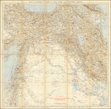
Fine vintage Hebrew-language map of the Middle East, stretching from the Indian border in the east to Egypt in the west. The map was issued in 1958 by the Israeli Department of the Navy.
The map shows fine detail throughout the Middle East, with roads, cities, pipelines, and more shown. Railroads are shown, mostly limited to the northern and the western parts of the map, with the Arabian Peninsula still little developed. All place names are provided in Hebrew.
The map is particularly fascinating for its completely different and outdated drawing of borders: the diamond-shaped Iraq-Saudi neutral zone is shown, the United Arab Emirates extends to Qatar, and Yemen's two-state configuration of borders is guessed at. Oman possesses a curving border pushed closer to the coast than at the present day. Israel's borders have been redrawn manually, and it shows its own two-state solution. This is likely in reference to the Jordanian Annexation, which removed part of the West Bank from Palestinian control in 1950 but is now considered the West Bank.
The map was published at a particularly turbulent time in the Middle East and for Israel. Israeli independence had only come ten years prior, in 1948, and the Suez Crisis of 1956 had just reinforced Israel's military strength but shown that it did not have as much global political clout as previously thought. Israel's place was still tenuous, and it would not be until the Six-Day War of 1967 that it would be firmly entrenched in the Middle East.
![[ Catholic Missions in the Ottoman Empire ]. Carte Ecclesiastique de L'Empire Ottoman d'apres les Missiones Catholicae](https://storage.googleapis.com/raremaps/img/small/88303.jpg)