|
||

|

|
|

|
Remarkable Set of Manuscript Maps by Female Armchair Traveler Maria Wright Phelips
Fine set of six manuscript maps, hand-drawn by Maria Wright Phelips from ca. 1784. The maps depict the south of England, Cadiz and Gibraltar, the route from the Mediterranean to the Red Sea, and the road from Latakia to Aleppo to Basra. They are the fine products of an armchair traveler who observed the world via periodicals and books from her home in Somerset, a prime example of the influence of travel literature on eighteenth-century readers, and female readers in particular.
The maps shown include:
- "A Chart of the English Channel, &c:". The southern portion of England is shown, with France's Normandy, Brittany, and Picardy to the southeast. Each county is individually colored, including Somerset, where Maria spent most of her adult life. The map is quite detailed with many toponyms. Of particular note is the Eddistone (Eddystone) Lighthouse, which, when first constructed in 1699, was the world's first open ocean lighthouse.
- "A Plan and Chart of the Bay of Cadiz and the adjacent Coast". The detail of the symbols used is striking on this small map. Forts are shown with their red, star-like bastions in various shapes and the fortress city of Cadiz is shown in outline. Each city and village are marked with churches and buildings nestled atop a hill. Trees also dot the landscape, and a black, rectangular grid is used to show salt works. The route of a ferry, the road for ships, shallow areas, and the docks for galleons are just some of the charting details included.
- "A Plan & Chart of the Bay of Gibraltar and the adjacent Coast". Highly detailed, like the Cadiz map, this sketch shows the highly fortified peninsula of Gibraltar, whose walls and bastions are outlined in red. The nearby Spanish settlements are shown via their churches and of particular interest is the Spanish Line, marked in gold.
- "A Plan and Chart of the Streights, the Bay of Gibraltar, with the opposite Coasts of Spain, and Morocco, in Africa". This map zooms out beyond the previous two, showing the Spanish coast from Cadiz to Malaga, and the African coast to the south. Forts and churches line the Spanish coastline, while in Morocco settlement is marked with mosques topped with the crescent moon, a symbol of Islam.
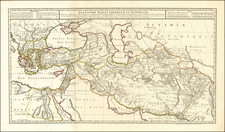
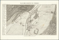
- "A Sketch of Egypt & The Routes both ancient & Modern from the Red Sea to the Mediterranean". The final two maps differ in style from the previous examples in that they are copied from the Observations on the Passage to India by James Capper. They have a grid of latitude and longitude. Some of the names are ancient, others modern, and the main focus is the Nile River, which flows somewhat parallel to the Red Sea to the east.
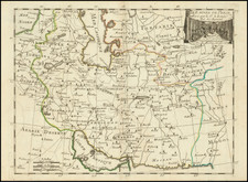
- "A sketch of the Route Across the Great Desert of Arabia From Latichea by Aleppo to Bassora." The largest map, also from the Observations, this map carries Maria's signature and date just below the title in the lower left corner. In pink is marked a journey from the Syrian port city of Latakia, written as Latichea here, to Aleppo to Basra, in modern Iraq. Along the way are numerous mountain ranges and settlements, marked again with the upturned crescent. As with the previous map, she gives the page numbers from the Weekly Entertainer which ran a review of the book for five weeks.
The sources and travel literature in the eighteenth century
The two maps from the Weekly Entertainer detail the travels of Colonel James Capper. In 1783, Capper published Observations on the Passage to India, through Egypt, and across the great Desert; with occasional remarks on the adjacent countries, and also sketches of the different routes. The work was published by the mapmaker William Faden, as well as J. Robson and R. Sewell.
Capper, an employee of the East India Company (EIC), was describing a journey from Leghorn to Latakia, then overland to India via Basra which he undertook in 1778. His main aim was to encourage the Directors of the EIC, to whom the book is dedicated, to pursue an open route of trade via Suez so as to lend the Company a trade and communications network from India to England all year round, via either the Cape of Good Hope, Suez, or Basra.
Curiously, Maria dates her route map 1782, but the Weekly Entertainer she cites did not exist until 1784; the story ran in the March 15, 22, 29, and April 5, 12 issues of that year, precisely matching the page numbers she cited on the route and Egypt maps. From the surviving evidence, it is likely that Maria copied the maps from Capper's book while also following along with the review as it was published in the magazine.
The source of the other maps is unknown, but it is possible that they were taken from another publication or were drawn from a compilation of other maps available to Maria at her home in Somerset. Either way, her ingenuity and attention to detail are evident. Maria's production of these maps ties her to two larger phenomena, namely the importance of travel literature to eighteenth-century British, and European, society and the increasing number of women interested in and working with maps.
Travel literature was one of the most popular genres of reading material available in the eighteenth century, for female and male readers. Books discussing voyages to the East, including India and the East Indies, were especially popular, as they were both exotic and instructive. Capper's book in particular discussed one of the important debates of the day, a trade route via Suez, which would peak with the construction of the Suez Canal in the mid-nineteenth century.
The fact that Maria is a female is notable and the survival of these maps is a remarkable example of a wider occurrence of more women participating in geography. Although the map industry was still dominated by men, widows and female relatives did sometimes inherit and successfully run map selling shops. Women were often employed as map colorists in the early modern period and some, mostly in France, were even engravers. The production of manuscript maps, such as these, however, is a much more difficult trend to track and has mostly been studied in the context of maps made by girls in school settings. The care and study it would have taken to create these maps indicates that women of certain educational backgrounds and socioeconomic statuses were indeed engaged with geography within their own homes.
Maria Wright Phelips
Born Maria Wright (ca. 1730-1793), Maria Phelips was the daughter of William Wright. She was baptized in Wednesbury, Staffordshire. She married Edward Phelips V (1727-1797) of Montacute in Somerset in 1747, when she was only 17. Edward served as an MP. Click here to see a portrait of Maria at 19 years of age, at Montacute House.
The couple had seven children together. One, John, served in the Royal Navy and died in 1781. Two sons, Edward and William, went on to serve as MPs. They also had another son, Charles, and three daughters, Elizabeth, Maria, and Rhoda.
Catstock (Cattistock), where Maria made these maps, is likely a reference to Catstock Lodge, a hunting lodge kept by the Phelips family. There is evidence of at least one other manuscript map drawn by Maria, indicating that the creation of these geographic gems was not an isolated incident, but a hobby that allowed her to dynamically consume geographic knowledge.
(1) 14.5 x 12;
(2) 15.5 x 12;
(3) 10.5 x 7.5;
(4) 14 x 9;
(5) 10.5 x 8;
(6) 20 x 13
Judith Tyner, “Mapping Women: Scholarship on Women in the History of Cartography,” Terrae Incognitae 48 (2016): 7-14. Link to the Weekly Entertainer: https://archive.org/details/weeklyentertain00unkngoog