|
||

|

|
|

|
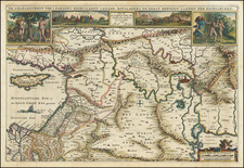
Scarce map of Persia and the Caspian Sea and adjoining regions, published in London by Herman Moll, based upon Carl Van Verden's landmark mapping of the Caspian.
A fine detailed map of the region at an interesting time in history. At the center of the map is the Caspian Sea, which was of great strategic importance at the time due to its location at the crossroads of Europe, Asia, and the Middle East. The map also includes detailed information about the region's geography, including mountain ranges, rivers, and deserts.
One of the most intriguing aspects of the map is the inclusion of the travels of Karl Van Verden, an explorer who journeyed through Central Asia in the early 18th century. Van Verden's journey is depicted on the map, with detailed annotations describing his route and the various cities and landmarks he encountered along the way.
Van Verden's journey began in Astrakhan, a city in modern-day Russia that was an important center of trade and commerce at the time. From there, he traveled south through the Caspian Sea region, passing through the city of Baku and eventually reaching the Iranian province of Gilan. Along the way, he encountered a diverse array of cultures and peoples, including the nomadic tribes of the region.
The inclusion of Van Verden's travels on the map speaks to the growing interest in exploration and discovery during the Age of Enlightenment. As Europe began to expand its influence around the globe, explorers and cartographers were eager to chart new territories and gain a deeper understanding of the world around them.
Carl Van Verden or Karl Van Verden, was a Dutch seaman in the employ of the Russian Navy during the early 18th century. Van Verden is best known for his important 1719 - 1721 mapping of the Caspian Sea, which was the most sophisticated and accurate that had been issued to date. A significant cartographic achievement, Van Verden's work on the Caspian led directly to Peter the Great's 1722 invasion of Baku and Derbent and Russian hegemony in the region. Despite his achievements in the Caspian, Van Verden was later passed up by the Czar in favor of Vitus Behring for the commission to discover a Northeast Passage through the Russian Arctic.
Herman Moll (c. 1654-1732) was one of the most important London mapmakers in the first half of the eighteenth century. Moll was probably born in Bremen, Germany, around 1654. He moved to London to escape the Scanian Wars. His earliest work was as an engraver for Moses Pitt on the production of the English Atlas, a failed work which landed Pitt in debtor's prison. Moll also engraved for Sir Jonas Moore, Grenville Collins, John Adair, and the Seller & Price firm. He published his first original maps in the early 1680s and had set up his own shop by the 1690s.
Moll's work quickly helped him become a member of a group which congregated at Jonathan's Coffee House at Number 20 Exchange Alley, Cornhill, where speculators met to trade stock. Moll's circle included the scientist Robert Hooke, the archaeologist William Stuckley, the authors Jonathan Swift and Daniel Defoe, and the intellectually-gifted pirates William Dampier, Woodes Rogers and William Hacke. From these contacts, Moll gained a great deal of privileged information that was included in his maps.
Over the course of his career, he published dozens of geographies, atlases, and histories, not to mention numerous sheet maps. His most famous works are Atlas Geographus, a monthly magazine that ran from 1708 to 1717, and The World Described (1715-54). He also frequently made maps for books, including those of Dampier’s publications and Swift’s Gulliver’s Travels. Moll died in 1732. It is likely that his plates passed to another contemporary, Thomas Bowles, after this death.
![(First state!) [ Iran, Eastern Iraq ] Tabula Asiae V](https://storage.googleapis.com/raremaps/img/small/95914.jpg)