This item has been sold, but you can enter your email address to be notified if another example becomes available.


|
||

|

|
|

|
Stock# 79032
Description
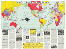
Interesting set of World maps, highlighting the various major air travel route around the globe.
The map employs 4 different projections to illustrate the various air routes of the period, which are shown as follows:
- Principal World Air Routes (thick red line)
- Secondary World Air Routes (thin red line)
- Other Air routes (thinnest red line)
The 4 projections are:
- "Nordic" Projection, designed by John Bartholemew. An Oblique Area-true Projection designed to give optimum representation to Europe and to routes in the Atlantic, Arctic and Indian Ocenas.
- North Polar Basin - Gnomic Projection
- "Nordic Projection - oriented to show the North Pacific at the center
- The Antipodes - Zenithal Equidistant Projection
![Western Hemisphere [and] Eastern Hemisphere](https://storage.googleapis.com/raremaps/img/small/77831.jpg)