


|
||

|

|
|

|
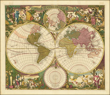
A little gem of map, being John Seller's representation of the ancient concept of zones of the earth, published in his miniature Atlas Terrestris, circa 1700.
The map is a great example of the characteristic Seller engraving style, with the sun and the moon overseeing the globe, which itself is divided into "Poler circle", Temperate Zone, and Torid Zone in both the northern and southern hemispheres.
The concept of geographical zones is most closely associated with Aristotle, though the concept was first promulgated by Parmenides.
John Seller was one of the most notable map and instrument makers in England in the late-seventeenth century. He was especially known for the sea charts, many of which featured in his influential English Pilot and Atlas Maritimus. Seller was born in London in 1632. His father was a cordwainer and John was apprenticed to Edward Lowe, of the Merchant Taylors’ Company. He was made free of that company in 1654. Later, he also was made a brother of the Clockmakers’ Company, which housed several instrument makers. He started business as a compass maker but expanded his offering to include navigational instruments and charts.
Seller’s career was halted temporarily, and fantastically, when he was tried for high treason in 1662. He was accused of involvement in a plot led by Thomas Tonge. While Seller likely only unwisely repeated rumors, he was convicted. The other conspirators, who did admit some degree of guilt, were executed, but Seller maintained his innocence and, via insistent petitions, he eventually secured his release from Newgate Prison.
This episode did not seem to slow Seller’s rise too much, however. Seller was granted a royal license to publish English-language maritime atlases. This gave him a near-monopoly and led to his being named hydrographer to the King in 1671. Although the point of the project was to produce English charts of Dutch dominance and bias, Seller ended up using many Dutch plates as his base material. The first volume of The English Pilot was published in 1671, followed by more volumes as well as The Coating Pilot (1672) and the Atlas Maritimus (1675). Seller was commercially successful, but some of his projects required further support. The English Pilot was eventually taken over by John Thornton and William Fisher, for example, and his proposed English atlas only produced maps of six counties.
Seller’s sons, John and Jeremiah, followed in their father’s profession. Seller also apprenticed several promising young men, including Charles Price, with whom his sons partnered. Through Price, Seller can be seen as the founding figure of an important group of London mapmakers that included Price, John Senex, Emanuel Bowen, Thomas Kitchin, and Thomas Jefferys.
![(World) ЗАПАДНОЕ ПОЛУШАРИЕ | ВОСТОЧНОЕ ПОЛУШАРИЕ [Western Hemisphere | Eastern Hemisphere]](https://storage.googleapis.com/raremaps/img/small/90264.jpg)
![[ World ] Air France -- Sur Les Ailes D'Air France Decouvrez Le Monde A Votre Tour](https://storage.googleapis.com/raremaps/img/small/100053.jpg)