|
||

|

|
|

|
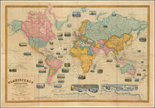
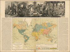
Western Hemisphere [and] Eastern Hemisphere, produced by John Tallis in London, 1851, offer detailed representations of the two hemispheres, each supplemented with twelve illustrative vignettes. This pair of maps, coming from the zenith of mid-19th-century atlas artistry, demonstrate geographical precision and provide an enlightening visual narrative of the era.
Commissioned for R. Montgomery Martin's Illustrated Atlas, these works bear the unmistakable imprint of Tallis's approach to map-making. Straddling the domains of utility and illustration, his maps offer a balance between the rigors of geography and the addition of visual context, making them valuable both as tools and as records of a bygone era.
John Tallis (1817-1876) was a British map publisher. Born in the Midlands, Tallis came to London in the 1840s. Tallis began his London career with a series of remarkable London street views. He began a partnership with a Frederick Tallis, possibly his brother, but their collaboration ended in 1849. For the Great Exhibition of 1851, Tallis published the Illustrated World Atlas, one of the last series of decorative world maps ever produced. The maps were engraved by John Rapkin, a skilled artisan. The maps were later reissued by the London Printing & Publishing Company, who left the Tallis imprint intact, thus ensuring his enduring fame. In 1858, he began publication of the popular Illustrated News of the World and National Portrait Gallery of Eminent Personages, selling it in 1861 (it ceased publication in 1863).
![Western Hemisphere. Eastern Hemisphere. [showin the Republic of Texas]](https://storage.googleapis.com/raremaps/img/small/82886.jpg)