


|
||

|

|
|

|
Stock# 69735
Description
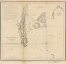
Very large wall map of a portion of San Diego, centered on City Heights and extending through the Mountain View and Southcrest neighborhoods to San Diego Bay in the lower-left corner of the map.
At the top edge of the map is Kensington and Kensington Heights.
The map provides an interesting look at these neighborhoods before they were carved up by the passage of the 5, 94, 15, and 805.
Condition Description
Mounted on wood rollers. The map is generally less toned in person than it appears in the image. Some toning and dampstaining at the bottom and top edges.
![(Southern California Photographs) [Western Travel Photo Album with Original Photographs of La Jolla, Los Angeles, Ocean Park (Santa Monica), Venice, Mt. Lowe, California; also photos of Trinidad, Colorado, Arizona, Nova Scotia, and other locations; and a number of Southern California printed picture postcards]](https://storage.googleapis.com/raremaps/img/small/90545.jpg)
![[ Southern California Tourism ] Hunting and Fishing in Southern California on the Santa Fe](https://storage.googleapis.com/raremaps/img/small/101613.jpg)
![[Original photograph:] Alligator Head Point. La Jolla.](https://storage.googleapis.com/raremaps/img/small/82799.jpg)
![Partition of Rancho Mission of San Diego San Diego, California -- Made under Decree of Superior Court dated January 7th, 1885, By Chas. J. Fox, C.E, O.H. Borden, M.C. Woodson ] Referees. Filed January 14th 1886. J.M. Dodge, Clerk.](https://storage.googleapis.com/raremaps/img/small/101388.jpg)