|
||

|

|
|

|
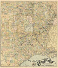
A separately-issued, detailed and extremely rare promotional map of Harris County Texas, published at a transitional moment in the region’s history.
Detailed lithographed separate map of Harris County, published in Houston by P. Whitty - Houston's main surveyor at the end of the 19th century.
Beginning of Houston as a Texas Powerhouse
The map was published in the immediate aftermath of two epochal events in the history of southeast Texas: the catastrophic Galveston Hurricane of 1900 and the discovery of oil at Spindletop in 1901, which launched the Texas oil industry generally and that of Trinity-Galveston Bay specifically. Those events helped propel Houston far ahead of Galveston as the most important entrepot in the region, a role on which it would build continually thereafter.
Though at the time of publication Houston was a relatively small city on the banks of Buffalo Bayou, in encompassing all of Harris County the map depicts what would grow into the present-day metropolis. The scale is at 6000 varas to the inch, a vara being 33 1/3 inches. The map is particularly useful for depicting property boundaries and landowners throughout the county, as well as the many rail lines that converged on the city and facilitated its rapid growth. The small inset map of the United States highlights Houston’s proximity to the Gulf of Mexico and the rail network tying it to the rest of the country. A table at bottom center drives home the promotional message by laying out some eye-catching statistics, including among other things the volume of cotton passing through the city, its dominant export before the oil boom of the early 20th century.
A table at bottom center elaborates Houston's demographic and economic vitals:
Taxable wealth $27,534,271
Population 71,156
Bank clearances 1901 $359,297,237
6 National and (Private banks) capital $3,500,000
Lines of railroad centering at Houston 15
Cotton received this season to Jany.1st 1,532,195
Cotton shipped through Buffalo Bayou to
the Gulf this seasons 1901 398,205
Editions
The map was first issued in 1899, the only apparent change to this 1902 version being the date (The only example I find of the first state for $1792.50 at Heritage Auctions on March 3, 2012.) Whitty issued a second map of Harris County in 1908, at the somewhat larger scale of 4500 varas to the inch.
Parick "P." Whitty was Houston's longest-tenured City Surveyor during the 19th century. His biography is well-summarized in the following excerpt from the Archaeological & Historical Commission of the City of Houston:
The Whitty clan had initially put down its Houston roots a mere six years after the end of the Civil War when Edmond’s father, young civil engineer Patrick Whitty, migrated to Houston from the Canadian province of Newfoundland. By 1872, he had moved his small family to a home in the Brunner section of Houston and established the Texas and Houston Land Company. 13 Mr. Whitty was the first Civil Engineer employed by the City of Houston, beginning his municipal employment in the administration of Mayor I.C. Lord in 1875 where he served in that capacity for nine years. He maintained a private practice as well, advertising in the City Directories of Houston for a number of years.
“Patrick Whitty: Civil Engineer and Surveyor. Land Boundary questions a speciality. On hand and for sale: Maps of all counties in Texas. Also maps of the City of Houston and all city additions. Maps made by blue print process, photo-litho process or lithograph process. Correspondence solicited. Office: 117 1/2 Main, Corner Franklin Avenue. Houston, Texas.”
Patrick Whitty was instrumental in placing and mapping many of Houston’s streets, parks, and neighborhoods. His involvement in the burgeoning city is evident. He laid out the lots for the Brunner Addition, the Magnolia Addition, Riverside Park, Kingwood, and Clear Lake areas held by Humble Oil and Refining. In fact on today’s city maps, Whitty Street parallels Jensen Drive and the Eastex Freeway. Since the third decade of the nineteenth century, it has been common practice to name city streets for those individuals who were important to either the entire city or those particular areas. Such is the case with Nagle Street, Tierweister, Reinerman, Baldwin, and Andrews Streets, all named for engineers, city councilmen, or developers. Houston, Harris County, and Texas maps and plats of the period abound with the notation “P. Whitty."
![[ Texas Oil Map ] Map of Terrell County Texas](https://storage.googleapis.com/raremaps/img/small/102589.jpg)
![Carte Des Antilles Du Golfe Du Mexique et d'une partie des Etats voisons…1842 [Republic of Texas]](https://storage.googleapis.com/raremaps/img/small/98848.jpg)