|
||

|

|
|

|
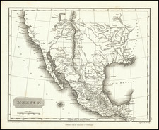
First Edition of the First Printed Map of the Republic of Texas (with Text Sheets!)
T.G. Bradford's 1835 map of Texas offers a striking illustration of the soon to be declared Republic of Texas. The map is often considered the first printed map of the Republic. A unique artifact of Texas history, the map showcases early features and settlements that existed before 1835.
The map is characterized by a mix of geographical and political detailing, highlighting the nascent Republic's infrastructure and land organization. Early roads are sketched, winding their way through the vast expanse of the Texan wilderness, connecting nascent settlements and trading posts.
The region labeled "Mustang Wild Horse Desert" stands out in South Texas. This area, known for its wild horse population, represents the untamed nature of early Texas and the challenges that early settlers faced in making this land their home. The map also emphasizes the Nueces River as the southwestern boundary with Mexico, underscoring the geopolitical tensions of the time and the evolving dynamics of Texas's borders. The land is divided into land grants, given to early settlers (known as empresarios) by the Mexican government, rather than counties - a nod to the Mexican administrative system.
Notable cities present on the map before 1835 would include San Antonio de Béxar, a major political and commercial center, Nacogdoches, an important gateway to the Spanish and, later, Mexican Texas, and Goliad, known then as La Bahía, a significant location for early Texas settlements. However, many well-known cities such as Houston and Austin are absent, as they were not established until after 1835. They were included in later editions of the map.
The map sketches out a number of the early Mexican land grants, which are identified as follows:
-
Stephen F. Austin's Grant: Stephen F. Austin, often referred to as the "Father of Texas," established the first Anglo-American colony in the Tejas province of Mexico, which later became Texas. He brought 300 families, known as the "Old Three Hundred," to settle the region in 1825, establishing a colony along the Brazos River.
-
Burnet's Grant: David G. Burnet, an early politician in the Republic of Texas, was granted land in December 1826 to settle 300 families. The land consisted of a part of the land granted to Haden Edwards, which Edwards had lost after the Fredonian Rebellion. Burnet made several attempts to establish a settlement, including an effort in Cincinnati in 1829. He would ultimately join with Zavala and Vehelein (see below), to form the Galveston Bay and Texas Land Company in October 1830. Burnet wrote several times to Stephen F. Austin about his colonization efforts prior to 1830.
-
DeWitt's Grant: Green DeWitt established a colony next to Austin's, near the Guadalupe River. The Mexican government approved his empresarial grant in 1825, allowing him to settle 400 families. The city of Gonzales was established as the capital of his colony.
-
Zavala's Grant: Lorenzo de Zavala, a Mexican politician, received a grant to settle 500 families in east Texas. However, he contracted with Joseph Vehlein and David G. Burnet to fulfill his contract due to his political duties, which would later become the infamous Galveston Bay and Texas Land Company.
-
John Cameron's Grant: There are two grants to Cameron on the map. John Cameron, early settler and soldier, was a native of Scotland. On May 21, 1827, the Mexican government granted him an empresario contract to introduce 100 families on the Colorado River in Texas. On September 12 the congress of Coahuila and Texas declared him a citizen. The contract was extended in 1832 for an additional three years. In 1828 he received a second contract to introduce 200 families on land along the Red River, an area previously contracted to Reuben Ross. This agreement was also extended in 1832 for an additional three years. No titles, however, were ever issued in consequence of either contract. Cameron received title to two leagues of land in the Power and Hewetson colony on October 31, 1834.
-
Félisola's Grant: Vicente Filisola was a military officer born in Ravello, Italy in 1789. He joined the Spanish army on March 17, 1804. He went to Mexico or New Spain in 1811. Although initially a Spanish Loyalist, Filisola held a number of important posts in the Republic of Mexico during the 1820s, and in January 1833 he was named commander of the Eastern Provincias Internas. On October 12, 1831, he received a grant to settle in Texas 600 families who were not Anglo-Americans. The area of his grant in East Texas included part of the land granted to the Cherokee Indians in 1823. Filisola failed to fulfill his contract with the government.
-
Austin & Williams' Grant: This refers to a joint grant made to Stephen F. Austin and Samuel M. Williams, which is better known in the history of Robertson's Colony. The colonization enterprise that eventually became known as Robertson's colony had previously been referred to as the Texas Association, Leftwich's Grant, the Nashville colony, or the upper colony. In the spring of 1830, Sterling Clack Robertson, one of the original stockholders of the Texas Association, acting under a subcontract with them and assisted by his partner, Alexander Thomson, Jr., began to recruit families and brought them to Texas, but the Law of April 6, 1830, prevented them from settling in the Nashville colony. However, they were allowed to settle in Austin's colony. Since Austin was preparing to go to the state capitol as deputy for Texas in the legislature, Robertson asked him to intervene for him, and Austin promised to do so. Instead, Austin applied for that same area, and obtained it, for himself and his secretary, Samuel May Williams.. The Austin and Williams contract was granted on February 25, 1831, and then the Nashville colony area was referred to as the upper colony of the Austin and Williams contract. Austin and Williams failed to get a land commissioner appointed, so they did not issue a single land title to actual settlers. However, they did sell permits to nonresident speculators to locate huge grants in that area. These grants, totalling 1,459,155 acres, later became involved in lawsuits and delayed the settling of Central Texas for many years. On May 22, 1834, the governor cancelled the Austin and Williams contract insofar as it affected the Nashville colony, and awarded a new contract to Sterling C. Robertson as empresario. Afterward, the area was called Robertson's colony. (Austin and Williams did get a decree passed on May 18, 1835, returning the colony to them, but it turned out that the state legislature did not have a constitutional quorum present when that decree was passed.)
-
Vehlein's Grant: Joseph Vehlein, a native of Germany, was an empresario who received a grant from Mexico to bring settlers to Texas. His land was located north and slightly west of Austin's colony. Joseph Vehlein received three empresario contracts to bring settlers to Texas under the Coahuila and Texas colonization law of March 24, 1825. With John Lucius Woodbury he received a contract on November 14, 1826, to settle 200 families, but although the contract date was extended to 1834, there is no evidence of any families located under the grant. A second contract of December 21, 1826, gave Vehlein permission to settle 300 families in the area between the Old San Antonio Road on the north, the coastal reserve on the south, the San Jacinto River on the west, and the border reserve on the east. The third contract, November 17, 1828, gave Vehlein the right to settle 100 families in the area south of his 1826 grant. Finding that he did not have sufficient capital to undertake colonization Vehlein combined his grants with those of David G. Burnet and Lorenzo de Zavala. On October 16, 1830, the three empresarios transferred their holdings to the Galveston Bay and Texas Land Company.
-
Beale's Grant: Likely refers to James Bowie and his brother Rezin's purchase of land from John Beale, another empresario. John Charles Beales came to Mexico from England as company surgeon with the Tlalpujahua Mining Association, a British-backed venture in the Mexican state of Michoacán. Before 1833 he gave up the practice of medicine to devote his time to promoting the development of several empresario contracts he acquired in the region north of the Rio Grande. In an eight-month period in 1832, he persuaded officials of the state of Coahuila and Texas to grant him and three different sets of partners three empresario contracts for an estimated 55 million acres of land north of the Rio Grande. The first of these, dated March 14, authorized Beales and José Manuel Royuela to settle 200 families on the same tract originally granted Stephen Julian Wilson in 1826. The second, issued on May 1, 1832, permitted the so-called Mexican Company (Beales and three Mexican partners) to locate 450 families on some 2 million acres in two parcels lying between the Colorado and Guadalupe Rivers that had been granted to Green DeWitt in 1825 and Benjamin Rush Milam in 1826. The third, dated October 9, 1832, permitted Beales and Dr. James Grant to settle 800 families on 8 million acres in two separate tracts–one lying between the Rio Grande and the Nueces, the other including that portion of the 1826 grant to John Lucius Woodbury and Joseph Vehlein lying east of the 100th meridian.
Beales again approached New York speculators. Between April 1833 and January 1835 he was intimately involved in the machinations of the directors of three land companies to which he sold his interests in the lands over which he had acquired control in 1832. To the New Arkansas and Texas Land Company, established in 1833, he ceded one-half of his interest in the Beales-Royuela grant; to the Rio Grande and Texas Land Company he deeded a large part of the Beales-Grant contract and the nine eleven-league purchases; and to the Colorado and Red River Land Company he transferred control over approximately one-half of the land in the Mexican Company contract lying between the Colorado and Guadalupe rivers. In addition he concluded agreements with a number of individuals, including John Woodward, to whom he passed title to some 4 million acres in different grants.
During the same period Beales spent much time and money recruiting colonists for a colonization project located between the Rio Grande and Nueces. In the end he was able to persuade fewer than 100 persons to settle at Dolores, the village named for his wife that he established in the area of present Kinney County on Las Moras Creek, some eighteen miles above its junction with the Rio Grande. Beales's attempt to plant a colony in that dry region came to an end when the colonists abandoned the site after the outbreak of the Texas Revolution.
-
Beale & Grant's Grant: (see above).
-
McMullin's and McGloine's Grant: The McMullen-McGloin colony was founded in 1828 by John McMullen and James McGloin after an empresario contract originally granted to John G. Purnell and Benjamin D. Lovell was relinquished. The contract called for settling 200 families on the left bank of the Nueces River above the coastal reserve. In the summer of 1829 McMullen and McGloin went to New York to recruit colonists. They targeted recently arrived Irish immigrants. After problems in transit by sea to Texas, the settlers congregated near the Santa Margarita Crossing, while the Mexican government official, José Antonio Saucedo, assigned their land. William O'Docharty, one of the colonists, surveyed the allotments.
In October 1831 the colonists laid out a town on the east bank of the Nueces, which they called San Patricio de Hibernia, or St. Patrick of Ireland, for the patron saint of their homeland. The original contract, calling for 200 families, was considered suspended by the Law of April 6, 1830, but in 1834 the empresarios secured a four-year extension, and by the outbreak of the Texas Revolution a total of eighty-four titles had been issued. By the eve of the Texas revolution, San Patricio was a thriving settlement with a population of nearly 500.
-
Power's Grant: James Power and James Hewetson, both Irish, received permission to settle 200 families of Irish and Mexican origin in Texas. Taking advantage of the colonization law of March 24, 1825, promulgated by the state of Coahuila and Texas, James Power and James Hewetson formed a partnership and applied for an empresario contract to colonize the Texas coast with Irish Catholic and Mexican families. Their original petition of September 29, 1826, for the coastal lands extending from the Nueces to the Sabine was modified on June 11, 1828, when the national government and the state of Coahuila granted them ten littoral leagues lying between the Lavaca and Guadalupe rivers. On March 13, 1829, Power and Hewetson asked for an increase in territory. On April 12, 1829, the assigned territory was extended from the Guadalupe to the Nueces, and on May 29, 1831, Power and Hewetson received control of the former lands of the abandoned Nuestra Señora del Refugio Mission. Between 1829 and 1831 many conflicts arose with the other empresarios in the area, Martin De León, John McMullen, and James McGloin. In settlement of the boundary disputes with De León, Power and Hewetson compromised by accepting the littoral lands lying between Coleto Creek and the mouth of the Nueces River.
Power went to Ireland in 1833 and returned with about 350 Irish immigrants. In 1834 these settlers received their legal allotment of lands from the commissioner, José Jesús Vidaurri. The same year Refugio Municipality was established, and lots, surveyed by James Bray, were distributed free to the colonists. Hewetson came to the colony to assist in the issuance of titles and obtained a headright for himself. He returned to Mexico, however, and in 1835 met Power at Mier and sold him his interest in the colony.
-
De Leon's Grant: Martín De León founded the only predominantly Mexican colony in Texas. His land grant was in the southern part of the region, and he established a colony along the Guadalupe River, where the city of Victoria stands today.
-
Austin's Colony: The first and most successful of the colonies, established by Stephen F. Austin. It's here that Austin settled the "Old Three Hundred."
An essential map for T
Thomas Gamaliel Bradford (1802-1887) was an American geographic publisher. He hailed from Bradford, Massachusetts and began his publishing career by working for the America Encyclopedia. Then, he edited and republished the Atlas Designed to Illustrate the Abridgement of Universal Geography, Modern & Ancient, which had originally been offered in French by Adrian Balbi. In 1835, he published another atlas, A Comprehensive Atlas: Geographical, Historical & Commercial, and, in 1838, An Illustrated Atlas Geographical, Statistical and Historical of the United States and Adjacent Countries. His interests were primarily in educational publishing and he was one of the first mapmakers to show Texas as an independent country.


![Carte De La Louisiane Et Du Cours Du Mississipi . . . Juin 1718 [1st State!]](https://storage.googleapis.com/raremaps/img/small/59797.jpg)