|
||

|

|
|

|
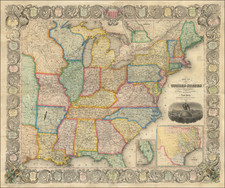
The Geographically Correct County Map Showing the Lines of the Cotton Belt Route and Connections is a detailed map that delineates the expansive railroad network extending from St. Louis to Texas. Published circa 1900 by the St. Louis Southwestern Railway, it is a striking testament to the era's monumental infrastructural growth and an artifact of economic history.
The opening years of the 20th century were a transformative period in the United States, with the railroads acting as critical arteries for burgeoning commerce and communication. This particular map reflects this shift in transportational and economic paradigms, as it covers a large geographic area extending from Missouri to Texas, taking in Louisiana, Arkansas, Oklahoma, Indian Territory, and Kansas, each divided into counties.
The routes of the St. Louis Southwestern Railway, known as the Cotton Belt Route, are prominently displayed, originating in St. Louis and reaching key cities such as Waco and Ft. Worth. An additional line extends as far south as Laredo, with offshoots branching off the main lines to other cities. The map's detailed representation of these routes speaks to the critical role railroads played in connecting various parts of the country, facilitating the movement of goods, people, and ideas.
The Geographically Correct County Map is a rich visual encapsulation of a key transitional moment in American history, presenting a detailed account of the railroad networks that served as the lifelines of a rapidly modernizing nation. It serves as an indelible link between America's industrial past and its contemporary infrastructural landscape.
![[ Republic of Texas ] A Map Of The Republic Of Texas And The Adjacent Territories, Indicating The Grants of Land Conceded Under the Empressario System of Mexico](https://storage.googleapis.com/raremaps/img/small/85444.jpg)
![[ Tennessee / Louisiana / Mississippi / Alabama ] Boston Mountains (408) Radar AAF Aeronautical Chart](https://storage.googleapis.com/raremaps/img/small/97161.jpg)
![[ Oil in the Oklahoma Panhandle ] Map of Cimarron County Oklahoma](https://storage.googleapis.com/raremaps/img/small/102584.jpg)