This item has been sold, but you can enter your email address to be notified if another example becomes available.


|
||

|

|
|

|
Stock# 29083
Description
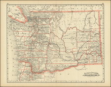
Early map showing a section of Duflot De Mofras' seminal map of the Western US and Canada.
Shows topography of the Pacific Northwest. Identifies islands and coastal features. Shows the locations of the Straits of Rosario involved in the border dispute between Great Britain and the United States.
Condition Description
Minor fold discoloration
![[Collection of 10 manuscript charts and maps depicting the west coast of North America from Monterey, California, to just north of Salisbury Sound, Alaska.]](https://storage.googleapis.com/raremaps/img/small/98898.jpg)
![[ Rare Early State! ] America's Greatest Scenic Asset The Columbia River Highway [cover title:] Portland Oregon featuring the Columbia River Highway](https://storage.googleapis.com/raremaps/img/small/77120.jpg)