


|
||

|

|
|

|
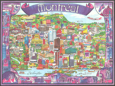
Rare Pictorial Map of Canada, Produced to Bolster Confidence in England During the Darkest Days of World War II
Colorful pictorial map of Canada, produced as part of the war effort to shore up confidence in the endless supply of material available in the New World, produced for a war-weary English populace.
The map lists the many resources available in the country, including furs, timber, textiles, coal, and a great deal of minerals. In two tiny parts of the country, fruit is produced. The map is replete with depictions of these resources and of shipments and weapons being sent across the Atlantic. The map includes a compass rose and the coat of arms of Canada.
The map reads:
All the enormous material resources of Canada and Newfoundland have been pledged, voluntary and wholeheartedly for the battle against the Axis. . . Canada's sons fight side by side with their British kin on battlefields throughout the world.
The map was designed by MacDonald Gill in 1942 and issued by the H. M. Stationery Office throughout the war.
The A[lf] C[ooke] Ltd. serial number "51/3191" has led some catalogers to conclude that the map was printed in 1951. While this is possible, it seems highly unlikely given that all examples at the Imperial War Museum and other institutions (and other maps from the same series, i.e., Australia and New Zealand) have the same "51"-prefixed serial numbers and are there said to have been produced in 1942.
Rarity
We find no other examples of this map having traded on Rare Book Hub. OCLC lists seven institutional examples of the map. An additional example resides in the David Rumsey Collection.
![(Second World War - The Budapest Ghetto) Budapest székesfőváros VII. ker. térképe [Map of the VII Area in the Capital City of Budapest]](https://storage.googleapis.com/raremaps/img/small/90122.jpg)
![[Japanese Invasion of Manchuria] Far East / War Fever](https://storage.googleapis.com/raremaps/img/small/63382.jpg)