|
||

|

|
|

|
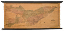
Stock# 83292
Description
Fine late 19th Century map of Ottawa, published by Might's Directory Company in 1891.
The map identifies wards, street names and early rail lines, along with Government buildings and parks.. The map includes a numbered and lettered grid, for ease of use with the index at the sides.
At the time, the population of Ottawa was about 44,000.
A list of other maps and publications by Might's Directory Company is also given.
Rarity
The map is apparently unrecorded. OCLC locates a reduced size photocopy at Brock University.
![[Nova Scotia Railway -- Shubenacadie Canal] (Hand Drawn Survey Maps)](https://storage.googleapis.com/raremaps/img/small/92802.jpg)