|
||

|

|
|

|
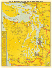
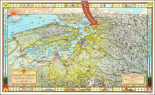
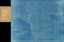
Striking bird's-eye view map of the Columbia River Valley, by Fred A. Routledge.
Oriented to look from the northwest, the map extends north of the Dalles to the Pacific Ocean, centered on Portland, and extends south to Crescent City and Klamath Falls, covering much of the state of Oregon. The map displays topographical relief, along with rivers, roads, railroad lines, and the course of the Columbia River and many of its tributaries.
Routledge was perhaps the best mapmaker in Oregon history; his work exemplifies the stylized realism of the first decades of the 20th century. This style matched modern mapmaking techniques with the budding pictorial mapping tradition, and incorporated the revelations provided by commercial air travel and photography.
The images on the front include the following:
Index to Illustrations
- No. 1—Celilo Falls on the upper Columbia River.
- No. 2—Highway through Hood River Valley.
- No. 3—Dry masonry supporting wall, Columbia River Highway.
- No. 4—At Mitchells Point.
- No. 5—Window in tunnel at Mitchells Point.
- No. 6—Tunnel under Mitchells Point.
- No. 7—Fish Hatchery at Bonneville, largest in world.
- No. 8—Wahkeena Falls.
- No. 9—Thirty-five miles of river and color, looking West from below Crown Point. No. 10—A Columbia River Fish Wheel. No. 11—Thirty-five miles of river and color, looking East from below Crown Point. No. 12—Multnomah Falls. No. 13—Latourelle Falls. No. 14—Benson Bridge at Multnomah Falls. No. 15—Supported Highway around Crown Point. No. 16—Intimate view of Crown Point, 700 feet above the Columbia River. No. 17—Horsetail Falls. No. 18—Shepherds Dell Bridge. No. 19—Viaduct over rock slide.
- No. 20—Bridal Veil Falls.
- No. 21—Where the Columbia River Highway approaches the sea.
- No. 22—Lower harbor from Clatsop Crest
The verso includes the following images:
- Crater Lake from Mt. Scott.
- By the blue water of Crater Lake.
- Lake Tahkenitch, near Marshfield.
- Wizard Island, Crater Lake.
- Glimpse of Portland’s retail district. 6, 7, 8, 9. Portland’s great fresh-water harbor, showing the “Jack Knife” bridge over the Willamette, and the battleship South Dakota of the United States navy.
- 10, 11, 12. Portland homes are surrounded by beauty and charm; rose hedges bloom through most of each year.
- 13, 14, 15. Millions of roses are used during the Rose Festival each year when Portland abandons business and plays among the roses.
- “Sacajawea” and “The Coming of the White Man,” historical statues in Washington Park.
- Section of Portland’s Annual Floral Exhibition.
- A view of Portland from City Park.
Fred Routledge (1871-1936) was an Oregon artist and pictorial mapmaker, who spent much of his professional life as a correspondent for the Morning Oregonian. His career lasted from the 1890s to the early 1930s. Routledge was a well regarded artist, who received awards for his paintings, including a first prize at the 1915 Panama-Pacific Exposition in San Francisco. His ephemeral work as a pictorial cartographer was also very well regarded.
Routledge was born in Abilene, Kansas, raised in Rockford, Illinois, and settled in the Portland area in 1886 with his family. He began working as an illustrator with the West Shore publication before its demise in 1891, thereafter finding wor at the Oregonian in 1895. The January 1, 1896 "Where Rolls the Oregon," is his first work of significant note.
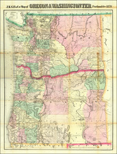
![[Washington & Oregon] Amer. Sep. No. 38. Partie Des Etats-Unis](https://storage.googleapis.com/raremaps/img/small/93549.jpg)