|
||

|

|
|

|
Important historical document, detailing the relationship between Reading Howell, the maker of one of the most important maps of Pennsylvania of the 18th Century, and James Phillips, the London engraver and printer who was responsible for the production of the copper plates used to print Howell's map.
The letter reflects Reading Howell's receipt of the 4 copper plates and 320 copies of Howell's 4-sheet map of Pennsylvania, one of the most important Pennsylvania maps published in the 18th Century. Howell expresses his satisfaction with the engraving work and that had he known the work would be so well executed, he would have had more copies of the map printed in London. He goes on to note that additional work would need to be done to the plates, which he was hopeful Phillips would undertake when needed (suggesting that the copper plates almost certainly made multiple trips across the Atlantic).
Little is known about Reading Howell. While it was known that his map was published in London, the details of publication set forth in this letter shed significant new light on the events which preceded the publication of the map and provide a fascinating insight into the relationship between Phillips and Howell. A transcription of the letter is set forth below.
Philadelphia 1st, 10mo 1792
James Phillips
Respected Friend
I received thy letters of the 3d, 5th, 14th and 26th of 7mo. and 4th of the 8th mo. with the respective bills of lading, Their contents came all safe to hand. viz 320 Maps in Sheets and 6 Reams of large paper for copper plates. All the Maps arrived before the expiration of the limited time. I am nevertheless satisfied with thy precautions to secure the donation.
The engraving is esteemed elegant. I am well pleased with its general appearance. But it is perhaps rather light and delicate, and will need retouching sooner on that account.
In descending to particulars I find sundry omissions and some few mistakes, but are generally of little moment. It is nevertheless upon the whole executed with more precision than I expected otherwise I should have directed more printing to have been done in your City.
I find thou hast secured the Map from piracy and fixed on its selling price with you which I am well pleased with.
When the plates want retouching I expect I shall send them back for that purpose. provided thou will accept of the charge.
I read the detail of thy trouble and disappointment in this undertaking with disagreeable feelings. But as thy labour is crowned with success I hope they will on reflection afford thee no disagreeable sensations. I have however to acknowledge thy favour and ever hold it in greatful rememberance.
I am thy respectful Friend,
Reading Howell
London ? Packet.
Reading Howell (1743–1827) was a distinguished American engineer, surveyor, and landowner, based in Pennsylvania, whose professional life spanned the transformative period from colonial times through the early years of the United States. Renowned for his surveying and cartographic skills, Howell played a pivotal role in the mapping and development of Pennsylvania during the late 18th and early 19th centuries.
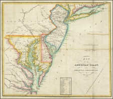
Born into the era preceding the American Revolutionary War, Howell's contributions to surveying began to gain prominence as the newly formed United States embarked on establishing its geographic and civic infrastructures. His work included detailed surveys of major Pennsylvania waterways—the Delaware, Lehigh, and Schuylkill Rivers—which were critical for commerce and transportation in the burgeoning nation.
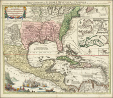
In 1789, recognizing his expertise, the Pennsylvania assembly commissioned Howell to create a comprehensive map of the state for the substantial sum of two hundred pounds. Published in 1792, this map was the first of Pennsylvania to be issued after the American Revolutionary War. It stood out as the most detailed and accurate representation of the state at the time, incorporating extensive cartographic data accumulated by both American and British military surveyors during the war. This map not only served as a vital tool for state planning and development but also as a significant artifact in the cartographic history of the United States.
From 1804 until his death in 1827, Howell held prominent civic roles in Philadelphia, including "Principal City Surveyor" and "City Regulator." In these capacities, he was intimately involved in urban planning and the resolution of land disputes, leaving an indelible mark on the physical and legal landscape of the city. His surveys and maps became authoritative resources, used extensively in legal settings and city planning.
Howell’s legacy is cemented in the annals of American surveying and cartography, with his early works remaining a reference point for historians and cartographers studying the post-revolutionary period. His meticulous records and maps continue to be valued for their historical significance and precision, reflecting the foundational years of American geography and the critical role of surveyors in shaping the nation’s early development.