|
||

|

|
|

|
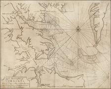
Rare separately issued coastal chart of the Coast of the United States, from Nantucket to Cape Hatteras.
Includes lighthouses, soundings, place names, notes and sailing directions.
The present example is published on thick paper and was never folded, with the lighthouses colored.
The United States Office of the Coast Survey began in 1807, when Thomas Jefferson founded the Survey of the Coast. However, the fledgling office was plagued by the War of 1812 and disagreements over whether it should be civilian or military controlled. The entity was re-founded in 1832 with Ferdinand Rudolph Hassler as its superintendent. Although a civilian agency, many military officers served the office; army officers tended to perform the topographic surveys, while naval officers conducted the hydrographic work.
The Survey’s history was greatly affected by larger events in American history. During the Civil War, while the agency was led by Alexander Dallas Bache (Benjamin Franklin’s grandson), the Survey provided the Union army with charts. Survey personnel accompanied blockading squadrons in the field, making new charts in the process.
After the Civil War, as the country was settled, the Coast Survey sent parties to make new maps, employing scientists and naturalists like John Muir and Louis Agassiz in the process. By 1926, the Survey expanded their purview further to include aeronautical charts. During the Great Depression, the Coast Survey employed over 10,000 people and in the Second World War the office oversaw the production of 100 million maps for the Allies. Since 1970, the Coastal and Geodetic Survey has formed part of the National Oceanic and Atmospheric Administration (NOAA) and it is still producing navigational products and services today.
![[ Virginia / Maryland / Chesapeake Region ] Pas Kaart van de Zee Kusten van Virginia Tusschen C. Henry ent Hooge Land van Renslaars Hoek. . .](https://storage.googleapis.com/raremaps/img/small/47255.jpg)