


|
||

|

|
|

|
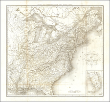
Early Appearance of Symmes Purchase in Western Ohio
Rare map of the United States, often lacking from Scott's Gazetteer.
The map locates the original 13 colonies, along with Vermont, Maine and Kentucky.
Includes a rare appearance of S[outh] W[est] Territory, the short-lived territorial name for Tennessee, as well as massive oversized Georgia and the Northwest Territory, which had been created in 1787 and then consisted of Ohio, Michigan, Wisconsin, Indiana, Illinois and part of Northern Minnesota.
In the future state of Ohio, the Seven Ranges, Ohio Company Lands, Donation Lands, Army Lands, and lands received by Colonel Simmes from the Commonwealth of Virginia are noted, a reference to Colonel John Cleve Symmes of New New York. Symmes bought 311,682 acres from the Congress in 1788, with the patent signed by President George Washington on October 30, 1794. This land was known as the Symmes Purchase, and was the cause of considerable controversy in his lifetime and after. Other partners included General Dayton and Elias Boudinot. There were disputes about the actual boundaries of the purchase and the quality of surveying and validity of titles. In the last years of his life, Symmes spent a great deal of time in court, defending himself from claims.
A number of other early land companies are shown in the Ohio Valley, including the Wabash Company, New Jersey Company and Illinois Company, along with a large section of Western Kentucky, which is noted as "Reserved for Virginia Troops," a reference to the lands then being given to American Revolutionary War veterans as compensation for time served during the war.


![Vereinigte Staaten Von Nordamerika [United States of America]](https://storage.googleapis.com/raremaps/img/small/79951.jpg)