|
||

|

|
|

|
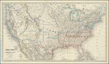
Rare variant edition of the first state of Lattre's map of the United States, the first French map to show the newly formed United States, published shortly after the Treaty of Peace in 1783.
As noted by Arkway in his 1998 catalogue of maps of the Great Lakes, the first state of Lattre's map "was the first French map to identify the newly formed United States." (Catalogue 50:167, describing a later state of the map published by Delamarche). Ristow calls the map "one of the most attractively designed and executed maps of the perod and reflects the talent and skill of the artist-cartographer."
In addition to being the first French map to recognize the newly formed United States, of particular note is the dedication to Benjamin Franklin, who is noted as Ambassador to France, delagate to the treaty negotiations and member of the Philosophical Society of Pennsylvania.
The map shows the region from Newfoundland to a northern Florida and west to beyond the Mississippi. Pennsylvania has an irregular western boundary and extends past Lake Erie in the north. The map provides a detailed treatment of the Indian Nations and River systems east of the Mississippi, along with a number of Forts and several French Missions in the Trans-Appalachian West. There is an inset of Florida (shown as an archipelago), with an ornate cartouche.
The present example does not include the list of the 13 colonies and the capitals of the colonies, which are present on all recorded examples located by collector Michael Hirsch during his survey of extent copies in 2009-2010.
A survey of examples described and/or illustrated in institutional collections shows that the map was folded at the time of issuance and all surviving examples which we encountered seem to have narrow to non-existent margins and some loss of printed image. The map survives in only a few examples and was of sufficient importance that it has been included in a facsimile edition published by the Donnelly Company in the Norman T. Leventhal Collection of the Boston Public Library. The example in the American Philosphical Society includes two text panels on the right and left of the map, which includes a description of the principal battles of the American Revolution.
Jean Lattré (fl. 1743-1793) was a Parisian bookseller and engraver who published many maps, plans, globes, and atlases. He worked closely with other important French cartographers, including Janvier, Bonne, and Delamarche, as well as other European mapmakers, such as William Faden, Santini, and Zannoni. Lattré is also interesting due to his propensity to bring suits against those who copied his work; plagiarism was common practice in eighteenth-century cartography and mapmakers struggled to maintain proprietary maps and information.
![[Map of the United States, illustrating the routes of the Canadian Pacific Railway and the Seattle, Lake Shore and Eastern Railway]](https://storage.googleapis.com/raremaps/img/small/71080.jpg)