|
||

|

|
|

|
Stock# 91681
Description
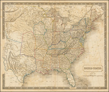
Detailed map of the United States and Canada. No West Viriginia shown. The Upper Peninsula is part of Wisconsin. A number of Indian Tribes are shown. Major cities, rivers, islands, bays, lakes, gulfs, mountains, etc. are shown. Includes decorative embellishments above the map and in the border. G.F. Cruchley was a mapseller and globemaker on Fleet Street in London in the mid-19th Century. His World Atlas, first published in 1854, was very unique for the period, employing vivid imagery and a striking print style, along with very distinctive coloring. Maps from his world atlas are relatively scarce on the market.
![United States of America [with] The Course of the River St. Laurence from Lake Ontarion to Manicouagan Point](https://storage.googleapis.com/raremaps/img/small/71643.jpg)
![[ British Colonies in North America ] Carte Nouvelle de L'Amerique Angloise contenant tout ce que les Anglois possedent sur le Continent de L'Amerique Septentrionale . . .](https://storage.googleapis.com/raremaps/img/small/100143.jpg)