Search
José Quiroga Méndez was a Spanish Jesuit missionary, sailor, mathematician, cartographer, and explorer.
Quiroga studied as a guardia marina and undertook studies in mathematics and physics at the Escuela Naval Española, with the intention of a career in the Spanish Navy. He participated in several maritime voyages. In 1736, he joined the Society of Jesus, studied Artes en el Colegio de Santiago Alfeo, and was ordained a priest in 1741 in Santiago de Compostela. Later, he headed to El Puerto de Santa María to continue his journey to the Rio de la Plata on an exploration mission of the Patagonian coast, to determine suitable points for the establishment of commercial ports while mapping the area and preaching the Gospel to the few indigenous people encountered in the American lands.
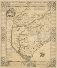
In Buenos Aires, he was part of a commission of pilots to calculate navigation courses and drew a plan of Buenos Aires, later published by the French Jesuit Charlevoix and known as the Charlevoix Plan. In 1746, Quiroga moved on to Córdoba, where he would later assist in forming a University and becoming its Mathematics chair. In 1749, he created a Map of the Jesuit missions between the Uruguay and Paraná rivers, which was printed in Rome in 1753.
Following the Treaty of Madrid (January 3, 1750), which redefined the long-contested borders between Spain and Portugal in South America, Quiroga played a significant part in cartographic mission to the former Jesuit mission areas.
Subsequently, the Governor of Buenos Aires, the Marquis of Valdelirios, enlisted Quiroga in an expedition to survey the border extending from Banda Oriental to what is now Bolivia.
The Pragmatic Sanction by Carlos III of Spain in 1767, mandating the Jesuits' expulsion from Spanish domains, compelled Quiroga to depart from Argentina, where he had been residing at the College of Belén in Buenos Aires. He subsequently reached Cádiz in 1768, before settling in Bologna, Italy, where he resumed his cartographic pursuits.
His magnum opus, the Mapa de las Missiones de la Compañia de Jesus en los rios Paraguay y Uruguay . . . is a cartographic masterpiece. It includes annotations about the Paraguay River's origin in Xarayes Lake and references the Yeipoliva and Yauri rivers, as well as Portuguese mining activities in Brazil's Matogrosso and Cubaya.
Quiroga also detailed various indigenous settlements. Of the Charrúas, he noted their nomadic lifestyle, sustenance through hunting and looting, and attire of Deer and Tiger skins. Their weaponry, beliefs, and practices were also described. Similarly, he depicted the Boanes, Ganoas, Minuares as sharing similar customs and armaments with the Charrúas. The Guañaras, he observed, were peaceful agrarians, supporting themselves through cultivation and hunting, with little known about their religious beliefs.
The Caribs, according to Quiroga, dwelled in dense forests east and west of the Uruguay River, subsisting on honey, wild fruits, and hunting, and were noted for their unique wax caps and large bows. He also mentioned the Payaguas, riverine nomads navigating the Paraguay and Paraná rivers, described as cruel and treacherous, with minimalistic canoes and simple weapons.
These detailed observations paint a vivid portrait of the Paraná River's communities, as seen through the eyes of the skilled cartographer and Jesuit missionary, José Quiroga Méndez, who meticulously documented the South American Jesuit missions in the mid-18th century.
In Córdoba, between 1763 and 1766, the University established the Chair of Advanced Mathematics and appointed Quiroga as its head.
Due to the Pragmatic Sanction of Carlos III of Spain in 1767, which expelled all Jesuits from Spanish possessions, Quiroga had to leave Argentina and settled in Bologna, Italy, where he continued his cartographic work. In Rome, he reported on the state of the Jesuit missions in Paraguay, leaving many manuscript observations, which he later included in the diary of his journey, published with Charlevoix's History of Paraguay. In Bologna, he wrote the Descripción en general de la provincia de Paraguay and el Tratado del arte de navegar, the latter being published in Córdoba shortly before his death in 1784.
Archived