|
||

|

|
|

|
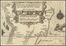
"The Most Perfect Map the Jesuits Made in the [18th] Century" (Furlong)
Well preserved example of one of the rarest 18th maps of the Jesuit Missions in South America, prepared by Father José Quiroga Méndez in 1749 and engraved in Rome by Ferdinandus Franceschelli in 1753, utlizing Quiroga's original manuscript maps.
Quiroga's map was engraved following the Treaty of Madrid on January 3, 1750, which began the effort by Spain and Portugal to end decades of conflict in the region and establish territorial boundaries between Portuguese Brazil and the Spanish colonial territories to the south and west. The map reflects the modern scientific rigor of its maker (identified on the map as Joseph Quiroga), who made the earliest astronomical surveys in the region. As noted by Alexander von Humboldt, “the missionaries [such as Quiroga] . . . were the only geographers of the most inland parts of the [American] continents.” Quiroga's map is described by Jesuit scholar Guillermo Furlong as the most perfect map the Jesuits made in the 18th century.
Quiroga's 1749 map covers the region of the Paraná and Uruguay rivers, including a detailed overview of the Missions from Paraguay and Uruguay to the mouth of the Rio de la Plata, locating the "towns" (settlements around the missions) within the region, along with an informative series of ethnographic notes which were part of Quiroga's more extensive observations on the region, a preview of his journal, which would remain unpublished for over a century.
Cartographically, the map is augmented by a list of 37 towns whose locations have been established by astronomical observations made by Quiroga on his expedition. To emphasize his rigor, Quiroga notes that the newly founded towns in the Tobatines, Minuanes, Mocovies, and Abipones are not included in the table, because the necessary astronomical observations had not been made, but are placed on the map in the position which he believed accurate based on available information.
Qurioga's Ethnographic Notes
In addition to the astronomical observations, Quiroga includes interesting ethnographic information, including the following observations on six different indigenous groups:
[The] Charruas [are] unfaithful Indians, horsemen, and nomads, who roam throughout the land south of the Ybera Lagoon between the Paraná and Uruguay rivers; they sustain themselves with hunting and what they steal; they dress in skins of Deer and Tigers, their bows, spears, and a branch with two or three stone balls are the weapons they use in war and hunting. It is not known if they acknowledge the true God, but it is certain they invoke the Devil in their drunkenness, and sometimes he appears to them visibly.
[The] Bohanes Ganoas [and] Minuanes . . . are nations of infidels, living in the plains to the East of the Uruguay River, and they have the same customs and weapons as we mentioned of the Charruas. [The] Guaraníes . . . live between the Paraná and Uruguay rivers from the Towns of the Missions to the Paraná Falls. They are pedestrian and naturally peaceful people, they cultivate the land, and sustain themselves with corn, and manioc, and hunting; their weapons are bows, arrows, and clubs: we know nothing certain of their Religion.
[The] Caribes live to the East and West of the Uruguay River in the thick forests; they sustain themselves on honey, wild fruits, and hunting; they wear a wax cap on their head as a hat, their weapons are large bows, which they shoot by anchoring one end in the ground: they eat the men they can capture.
[The] Payaguas . . . are infidels who spend most of their life on the rivers, and navigate the entire Paraguay River, and the Paraná from the towns of the Missions to the River Plate, using very small, and light canoes; the men go naked, and are very cruel, and treacherous; their weapons are spears, arrows, and clubs.
Creation and Publication of the Map
Quiroga's initial assignment in the New World was to undertake a detailed study and mapping of the coastline of Patagonia, beginning in 1746. The present work was his next significant cartographic contribution. Quiroga was next commissioned to map of the territory of Misiones: a vast and difficult undertaking, not only due to the nature of the terrain, but also due to the lack of materials and resources. His subsequent field work determined with great accuracy the geographical position of the towns of Misiones, and that of the cities of Asunción, Corrientes, Santa Fe, Colonia, Montevideo and Buenos Aires. From this information and the data provided by mostly unpublished reports of the missionaries, Quiroga created this monmental work, which was as tranmittd back to Rome and engraved by Ferdinandus Franceschelli.
The map is dedicated to Ferdinand VI, King of Spain, and includes his portrait in the allegorical dedicatipn cartouche, with the text below translating as follows: "Behold, what I know of the new world. O wealthiest of Kings, the fields of the Indians, the peaks of rocks, mountains, Rising hills, and cedar-roofed houses, Rivers which slide along their watery course, And accept the depicted steps of all these, Live."
A trained mapmaker, mathematician and skilled navigator, Father José Quiroga Méndez (1707 -1784) arrived in South America in 1745–1746, joining José Cardiel (1704–1781) Matthias Strobel (1696–1769) on a maritime expedition along the Patagonian coast as part of an effort to expand the Jesuit missions in the region south of Río de la Plata, along with the exploration of Patagonia, the Strait of Magellan, and Cape Horn, the first Spanish expedition in 1745-46 along the Patagonian coasts. Following the signing of the Treaty of Madrid, Quiroga would go on to play an active role in the boundary survey party that toured the Upper Paraguay River region.
The map includes a number of text explanations, which are outlined below:
"El rio Paraguay tiene su origen en el lago de los Xarayes en la Latitud de 14 grados al Sur de la Equinocial: entran en este lago por la banda de el Poniente los rios Ycipotiva, y Yauri, los cuales vienen de el Noroeste; suben por cualquiera de los dos los Portugueses, que van a las nuevas minas de Matogroso situadas en la ribera Septentrional de el Yauri, casi al Oeste de las otras minas de Cuyaba."
Translation: "The Paraguay River originates from the Xarayes Lake at the latitude of 14 degrees south of the Equator: entering this lake from the west are the Ycipotiva and Yauri rivers, which come from the Northwest. The Portuguese ascend either of these two rivers, heading to the new mines of Matogrosso located on the Northern bank of the Yauri, almost west of the other mines of Cuyaba."
Rarity
OCLC locates 2 examples:
- John Carter Brown Library
- National Library of Spain
- British Library (listed as a manuscript, but noting the Rome 1753 imprint, so likely printed)
The 1861 Catalogue of the manuscript maps, charts and plans ... in the British museum lists a copy of the map.
National Historical Archive of Madrid; Codex State, Proc. Leg. 3505. Sign. 682.
Humbolt, Personal Narrative of Travels to the Equinoctial Regions of America.
José Quiroga Méndez was a Spanish Jesuit missionary, sailor, mathematician, cartographer, and explorer.
Quiroga studied as a guardia marina and undertook studies in mathematics and physics at the Escuela Naval Española, with the intention of a career in the Spanish Navy. He participated in several maritime voyages. In 1736, he joined the Society of Jesus, studied Artes en el Colegio de Santiago Alfeo, and was ordained a priest in 1741 in Santiago de Compostela. Later, he headed to El Puerto de Santa María to continue his journey to the Rio de la Plata on an exploration mission of the Patagonian coast, to determine suitable points for the establishment of commercial ports while mapping the area and preaching the Gospel to the few indigenous people encountered in the American lands.
In Buenos Aires, he was part of a commission of pilots to calculate navigation courses and drew a plan of Buenos Aires, later published by the French Jesuit Charlevoix and known as the Charlevoix Plan. In 1746, Quiroga moved on to Córdoba, where he would later assist in forming a University and becoming its Mathematics chair. In 1749, he created a Map of the Jesuit missions between the Uruguay and Paraná rivers, which was printed in Rome in 1753.
Following the Treaty of Madrid (January 3, 1750), which redefined the long-contested borders between Spain and Portugal in South America, Quiroga played a significant part in cartographic mission to the former Jesuit mission areas.
Subsequently, the Governor of Buenos Aires, the Marquis of Valdelirios, enlisted Quiroga in an expedition to survey the border extending from Banda Oriental to what is now Bolivia.
The Pragmatic Sanction by Carlos III of Spain in 1767, mandating the Jesuits' expulsion from Spanish domains, compelled Quiroga to depart from Argentina, where he had been residing at the College of Belén in Buenos Aires. He subsequently reached Cádiz in 1768, before settling in Bologna, Italy, where he resumed his cartographic pursuits.
His magnum opus, the Mapa de las Missiones de la Compañia de Jesus en los rios Paraguay y Uruguay . . . is a cartographic masterpiece. It includes annotations about the Paraguay River's origin in Xarayes Lake and references the Yeipoliva and Yauri rivers, as well as Portuguese mining activities in Brazil's Matogrosso and Cubaya.
Quiroga also detailed various indigenous settlements. Of the Charrúas, he noted their nomadic lifestyle, sustenance through hunting and looting, and attire of Deer and Tiger skins. Their weaponry, beliefs, and practices were also described. Similarly, he depicted the Boanes, Ganoas, Minuares as sharing similar customs and armaments with the Charrúas. The Guañaras, he observed, were peaceful agrarians, supporting themselves through cultivation and hunting, with little known about their religious beliefs.
The Caribs, according to Quiroga, dwelled in dense forests east and west of the Uruguay River, subsisting on honey, wild fruits, and hunting, and were noted for their unique wax caps and large bows. He also mentioned the Payaguas, riverine nomads navigating the Paraguay and Paraná rivers, described as cruel and treacherous, with minimalistic canoes and simple weapons.
These detailed observations paint a vivid portrait of the Paraná River's communities, as seen through the eyes of the skilled cartographer and Jesuit missionary, José Quiroga Méndez, who meticulously documented the South American Jesuit missions in the mid-18th century.
In Córdoba, between 1763 and 1766, the University established the Chair of Advanced Mathematics and appointed Quiroga as its head.
Due to the Pragmatic Sanction of Carlos III of Spain in 1767, which expelled all Jesuits from Spanish possessions, Quiroga had to leave Argentina and settled in Bologna, Italy, where he continued his cartographic work. In Rome, he reported on the state of the Jesuit missions in Paraguay, leaving many manuscript observations, which he later included in the diary of his journey, published with Charlevoix's History of Paraguay. In Bologna, he wrote the Descripción en general de la provincia de Paraguay and el Tratado del arte de navegar, the latter being published in Córdoba shortly before his death in 1784.