|
||

|

|
|

|
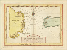
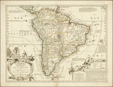
Rare Map of Central South America
Scarcely-seen map of the central part of South America, showing the region from Quito and Cap. D.S. Augustyn in the north to Porto Guasco, Isle S. Sebastian and Rio De Janeiro in the south.
The map shows the 1598-1601 voyage of Olivier van Noort, the first Dutchman to circumnavigate the earth, and the ninth navigator to do so overall.
This map appeared in the Van Geelkercken edition of Olivier Van Noort's Description Du Penible Voyage Ge Fait Entour De L'Univers ou Globe Terrestre . . . , which was first published by Cornelis Claesz in Amsterdam in 1602. The map can be distinguished from earlier editions of the work by a lack of a left border, suggesting that the map was printed from what was originally part of a larger copperplate. It can also be differentiated by the inclusion of the “12” in the lower right corner.
Van Noort's map, engraved by Dutch master engraver Baptista Van Deotecum, is one of the earliest and most detailed regional maps to show the eastern and western coastlines of the central part of South America, based upon first hand observations.
The map tracks Van Noort's arrival from the east, his first land fall near Rio De Janeiro and his course southward toward Patagonia. It then picks up in the west near "Porto Guasco” and tracks his journey northward to the area near Quito. The arrival of four ships on the east side of the map and then the depiction of only two ships on the west coast reflects the difficult journey Van Noort had in passing through the Straits of Magellan.
The first Dutch circumnavigation
Olivier van Noort was born in 1558 in Utrecht. He proved to be a successful merchant captain, sailing to distant locales for trade goods.
On July 2, 1598, he set off for a new destination: the eastern Pacific. Van Noort was leading a piratical expedition to raid ports in western South America and the Philippines, where the Spanish were vulnerable. He led a squadron of four ships. They were to harass Spanish trade and then cross the world’s largest ocean to trade in China.
Van Noort sailed south to Africa and then across the Atlantic to Portuguese Brazil. There, he had trouble finding a safe port for his crew, several of whom had fallen ill, until he found the island of Santa Clara (included on this map as I. de S. Clara).
As with Drake before him, van Noort found the navigation of the Straits of Magellan treacherous, losing two of his ships to stormy conditions. After trying to raid Spanish ports, he found that his arrival had been anticipated. Instead, he fled across the Pacific. There, he lost a third ship. Only one of his ships, the Mauritius, made it back to Rotterdam.
Nevertheless, van Noort was celebrated as a Dutch hero. The United Dutch East India Company (VOC) was formed a few months later. Van Noort's Description du Penible Voyage Faict entour de l'Univers ou Globe Terrestre provides his account of the voyage, including a detailed account of the coasts of Brazil, Argentina, the Straits of Magellan, Chile, Peru, and the subsequent trans-Pacific crossing. The maps and views, engraved by Baptista Van Deutecum and Benjamin Wright, are among the earliest printed regional images of the areas shown. The last complete example of the book to be sold at auction was sold at the Frank Streeter Sale (April 16, 2007), where it was sold for $45,600, including premium.
Rarity
The map is quite rare on the market, with only one prior example being offered at auction or in a dealer catalogue in the past thirty years (Potter 2004).
This is only the third example of the map we have had in the past twenty years.
Nicholas (sometimes Nicolaes, Nicolaas, or Nicolas) van Geelkercken (sometimes Geelkerken, or Geilekerck) (fl. 1600-1656) a Dutch cartographer from the 17th century, isn’t as prominently recognized as some of his peers. However, his contributions to the field are noteworthy and deserve attention. There's some debate over his birthplace; Waller suggests Scherpenzeel in Guelders, Hollstein posits Zutphen, and some even point to Geilenkirchen in Germany due to the similarity in name.
The first known record of Geelkerken’s work dates back to 1600, with a depiction of the Castle of Verwolde. Then, a decade-long gap ensues until 1610, when records show his various roles as a draughtsman, engraver, publisher, and surveyor. Initially, he lived in Leiden, briefly in Amsterdam around 1615 and 1616, and later moved to Arnhem after his appointment as the surveyor of Guelders. He passed away on September 25, 1656, and was succeeded by his son Isaak.
In 1610, Geelkerken produced a map of the world titled Universi Orbis Tabula De integro Delineata. This map, printed in Amsterdam, measured 41 by 56 cm and featured allegorical images of the then-known parts of the world. Notably, it showcased the voyages of notable explorers such as Magelhaen, Candish, Drake, and Van Noort.
By 1616, Geelkerken released another world map published by Johannes Janssonius. Although the first edition of this map hasn't been found, later editions from 1618 are available. This map, too, had details about famous explorers, and notably lacked updates about the discoveries of Schouten and Lemaire.
In 1619, Geelkerken published Oost ende West-Indische Spiegel, which detailed the voyages of Joris van Spilbergen and Schouten and Lemaire. Within this work was a world map, which later influenced the works of other cartographers.
One of Geelkerken's projects was also engraving for a map of Pomerania by Eilhard Lubin, which spanned 12 sheets and was quite detailed. Similarly, Geelkerken was involved in creating a map of Palestine in collaboration with his brother Arnoldus Geilkerkius, who had traveled to Palestine.
Apart from these, Geelkerken made significant contributions to the mapping of Friesland. In Ubbo Emmius' De Frisia et Frisiorum Republica, Geelkerken presented detailed plans of the Frisian towns. Furthermore, his map of Frisia, created in 1618, provided a comprehensive view of the region during that time.
Geelkerken’s work also included a 1621 map of Rhaetia and his participation in Phil. Cluverius' Italia antiqua in 1624. His dedication to the field was evident in the numerous war-maps and historical prints he engraved, particularly those related to the Julierswar of the early 1610s.
In summary, while Nicolaas Geelkerken might not be the most celebrated cartographer, his dedication to his craft and the multitude of maps he contributed to reflect his essential role in the cartography of the 17th century.
Olivier Van Noort was the first Dutchman to circumnavigate the globe, between 1598 and 1601.