|
||

|

|
|

|
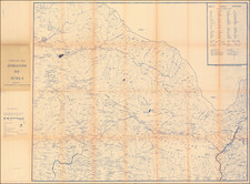
Fascinating postal and transportation map of India, published in London by James Wyld and first appeared in Wyld's atlas in 1849.
James Wyld's map, highlighting post roads and dawk (post) stations, would have been an important tool for navigation and understanding the communication networks in India at the time. It likely provided valuable information for travelers, merchants, and colonial administrators about the locations of these key postal stations and the routes connecting them. The map reflects the infrastructure and organization of the British colonial postal system in India, which played a crucial role in the administration and connectivity of the vast and diverse regions of the country.
Highly detailed map of India, focusing on the Post Roads and Dawk Stations, published shortly after the construction of the first Indian Railroads.
The key lists the following:
- Post and Banghy Roads
- Post Roads & Routes
- Banghy Roads
- Railroads
The map is color coded to show:
- British Possessions (Pink)
- Subsidiary States (Green)
- Protected States (Yellow)
- Independent States (Orange)
A "Dawk Station" refers to a postal station or relay point in the Indian postal system. The term "Dawk" (or "Dak") is derived from the Hindi word डाक (ḍāk), which means "post" or "mail". During the 19th century, in British India, the dawk system was an extensive postal and parcel service. Dawk stations were critical nodes in this network, serving as points where mail carriers, often on horseback or using palanquins, would exchange mailbags and parcels, or where couriers would rest before continuing their journey. These stations were strategically located along major routes to facilitate the swift and efficient transfer of correspondence across vast distances.
James Wyld Sr. (1790-1836) was a British cartographer and one of Europe’s leading mapmakers. He made many contributions to cartography, including the introduction of lithography into map printing in 1812.
William Faden, another celebrated cartographer, passed down his mapmaking business to Wyld in 1823. The quality and quantity of Faden’s maps, combined with Wyld’s considerable skill, brought Wyld great prestige.
Wyld was named geographer to Kings George IV and William IV, as well as HRH the Duke of York. In 1825, he was elected an Associate of the Institution of Civil Engineers. He was one of the founding members of the Royal Geographical Society in 1830. Also in 1830, his son, James Wyld Jr., took over his publishing house. Wyld Sr. died of overwork on October 14, 1836.
James Wyld Jr. (1812-87) was a renowned cartographer in his own right and he successfully carried on his father’s business. He gained the title of Geographer to the Queen and H.R.H. Prince Albert. Punch (1850) described him in humorous cartographic terms, “If Mr. Wyld’s brain should be ever discovered (we will be bound he has a Map of it inside his hat), we should like to have a peep at it, for we have a suspicion that the two hemispheres must be printed, varnished, and glazed, exactly like a pair of globes.”